Saint Johns geodata
Saint Johns (Michigan) is a seat of a second-order administrative division; located in United States in America/Detroit (GMT-4) time zone. With population of 7,865 people, there are 5346 cities with bigger population in this country. Compared to other cities in United States, 83.3% of cities are located further ↓South; 57.2% of cities are located further ←West and 61.4% of cities have lower elevation than Saint Johns. Note1


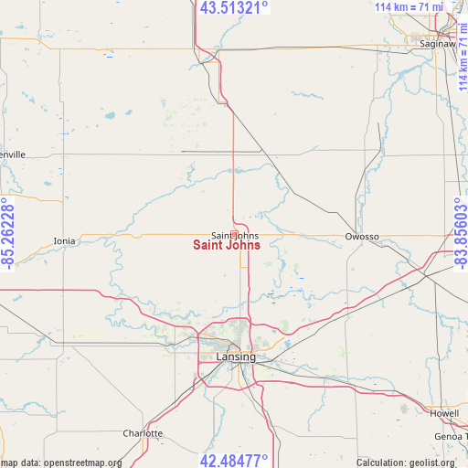
Saint Johns GPS coordinates[2]
43° 0' 4.104" North, 84° 33' 32.94" West
| Map corner | latitude | longitude |
|---|---|---|
| Upper-left | 43.51321°, | -85.26228° |
| Center: | 43.00114°, | -84.55915° |
| Lower-right: | 42.48477°, | -83.85603° |
| Map W x H: | 114.4×114.4 km | = 71.1×71.1mi |
| max Lat: | 71.29058° ⇑16.7% North |
| Saint Johns: | 43.00114° |
| min Lat: | ⇓83.3% South 19.06759° |
| min Long | Saint Johns | max Long |
| -171.73463° | -84.55915° | -66.98998° |
| W 57.2%⇐ | ⇒42.8% E |
Elevation
Elevation of Saint Johns is 246 m = 807 ft, and this is 48.8 m = 160 ft below average elevation for this country.
| Max E: |
3189 m = 10463 ft | 38.6% |
| Avg. | 294.8 m = 967 ft | |
| Saint Johns | 246 m = 807 ft | |
Min E: |
-60 m = -197 ft | 61.4% |
See also: United States elevation on elevation.city.
Geographical zone
Saint Johns is located in North temperate zone (between Tropic of Cancer and the Arctic Circle). Distance of this Northern Tropic circle is 2175.4 km =1351.7 mi to South.| Distance of | km | miles | from Saint Johns |
|---|---|---|---|
| North Pole | 5225.8 | 3247.2 | to North |
| Arctic Circle | 2619.9 | 1627.9 | to North |
| Tropic Cancer | 2175.4 | 1351.7 | to South |
| Equator | 4781.3 | 2971 | to South |


Nearby cities:
15 places around Saint Johns: (largest is in red/bold)
• Ashley
21.7 km =13.5 mi,  18°
18°
• Bath
22.2 km =13.8 mi,  156°
156°
• Carson City
30.4 km =18.9 mi,  309°
309°
• DeWitt
17.7 km =11 mi,  182°
182°
• East Lansing
30 km =18.6 mi,  168°
168°
• Edgemont Park
28.4 km =17.6 mi,  185°
185°
• Elsie
17 km =10.6 mi,  55°
55°
• Fowler
14.7 km =9.1 mi,  270°
270°
• Laingsburg
20.9 km =13 mi,  126°
126°
• Lansing
29.9 km =18.6 mi, 179°
• Maple Rapids
15.8 km =9.8 mi,  316°
316°
• Ovid
15.3 km =9.5 mi,  88°
88°
• Wacousta
22.5 km =14 mi,  210°
210°
• Waverly
29.6 km =18.4 mi, 189°
• Westphalia
21 km =13 mi,  247°
247°
Sources, notices
• [Note1] Compared only with cities in United States existing in our database
• [Src1] Map data: © OpenStreetMap contributors (CC-BY-SA)
• [Src2] Other city data from geonames.org with taken over terms of usage.
• [Src3] Geographical zone / Annual Mean Temperature by Robert A. Rohde @ Wikipedia
