Maple Rapids geodata
Maple Rapids (Michigan) is a populated place; located in United States in America/Detroit (GMT-4) time zone. With population of 678 people, there are 18889 cities with bigger population in this country. Compared to other cities in United States, 84.1% of cities are located further ↓South; 56.7% of cities are located further ←West and 53% of cities have lower elevation than Maple Rapids. Note1


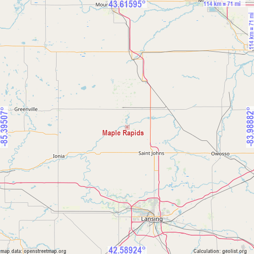
Maple Rapids GPS coordinates[2]
43° 6' 17.1" North, 84° 41' 30.984" West
| Map corner | latitude | longitude |
|---|---|---|
| Upper-left | 43.61595°, | -85.39507° |
| Center: | 43.10475°, | -84.69194° |
| Lower-right: | 42.58924°, | -83.98882° |
| Map W x H: | 114.2×114.2 km | = 71×71mi |
| max Lat: | 71.29058° ⇑15.9% North |
| Maple Rapids: | 43.10475° |
| min Lat: | ⇓84.1% South 19.06759° |
| min Long | Maple Rapids | max Long |
| -171.73463° | -84.69194° | -66.98998° |
| W 56.7%⇐ | ⇒43.3% E |
Elevation
Elevation of Maple Rapids is 210 m = 689 ft, and this is 84.8 m = 278 ft below average elevation for this country.
| Max E: |
3189 m = 10463 ft | 47% |
| Avg. | 294.8 m = 967 ft | |
| Maple Rapids | 210 m = 689 ft | |
Min E: |
-60 m = -197 ft | 53% |
See also: United States elevation on elevation.city.
Geographical zone
Maple Rapids is located in North temperate zone (between Tropic of Cancer and the Arctic Circle). Distance of this Northern Tropic circle is 2186.9 km =1358.9 mi to South.| Distance of | km | miles | from Maple Rapids |
|---|---|---|---|
| North Pole | 5214.3 | 3240 | to North |
| Arctic Circle | 2608.4 | 1620.8 | to North |
| Tropic Cancer | 2186.9 | 1358.9 | to South |
| Equator | 4792.8 | 2978.1 | to South |


Nearby cities:
15 places around Maple Rapids: (largest is in red/bold)
• Alma
30.6 km =19 mi,  4°
4°
• Ashley
19.9 km =12.4 mi,  62°
62°
• Carson City
14.9 km =9.3 mi,  302°
302°
• DeWitt
30.8 km =19.1 mi,  161°
161°
• Elsie
24.8 km =15.4 mi,  94°
94°
• Fowler
12.1 km =7.5 mi,  198°
198°
• Ithaca
21.9 km =13.6 mi,  18°
18°
• Lyons
24.8 km =15.4 mi,  236°
236°
• Muir
23.7 km =14.7 mi, 239°
• Ovid
28.3 km =17.6 mi,  112°
112°
• Portland
31.3 km =19.4 mi,  213°
213°
• Saint Johns
15.8 km =9.8 mi,  136°
136°
• Sheridan
33.2 km =20.6 mi,  291°
291°
• Wacousta
30.8 km =19.1 mi,  181°
181°
• Westphalia
21.3 km =13.2 mi, 203°
Sources, notices
• [Note1] Compared only with cities in United States existing in our database
• [Src1] Map data: © OpenStreetMap contributors (CC-BY-SA)
• [Src2] Other city data from geonames.org with taken over terms of usage.
• [Src3] Geographical zone / Annual Mean Temperature by Robert A. Rohde @ Wikipedia
