Cottage Grove geodata
Cottage Grove (Minnesota) is a populated place; located in United States in America/Chicago (GMT-5) time zone. With population of 35,918 people, there are 1367 cities with bigger population in this country. Compared to other cities in United States, 91.8% of cities are located further ↓South; 66.1% of cities are located further →East and 61.4% of cities have lower elevation than Cottage Grove. Note1
Administrative division(s):
- Level 1: Minnesota
- Level 2: Washington County
- Level 3: City of Cottage Grove


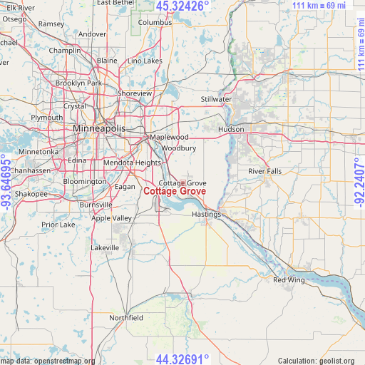
Cottage Grove GPS coordinates[2]
44° 49' 39.864" North, 92° 56' 37.752" West
| Map corner | latitude | longitude |
|---|---|---|
| Upper-left | 45.32426°, | -93.64695° |
| Center: | 44.82774°, | -92.94382° |
| Lower-right: | 44.32691°, | -92.2407° |
| Map W x H: | 110.9×110.9 km | = 68.9×68.9mi |
| max Lat: | 71.29058° ⇑8.2% North |
| Cottage Grove: | 44.82774° |
| min Lat: | ⇓91.8% South 19.06759° |
| min Long | Cottage Grove | max Long |
| -171.73463° | -92.94382° | -66.98998° |
| W 33.9%⇐ | ⇒66.1% E |
Elevation
Elevation of Cottage Grove is 246 m = 807 ft, and this is 48.8 m = 160 ft below average elevation for this country.
| Max E: |
3189 m = 10463 ft | 38.6% |
| Avg. | 294.8 m = 967 ft | |
| Cottage Grove | 246 m = 807 ft | |
Min E: |
-60 m = -197 ft | 61.4% |
See also: United States elevation on elevation.city.
Geographical zone
Cottage Grove is located in North temperate zone (between Tropic of Cancer and the Arctic Circle). Distance of this Northern Tropic circle is 2378.5 km =1477.9 mi to South.| Distance of | km | miles | from Cottage Grove |
|---|---|---|---|
| North Pole | 5022.7 | 3121 | to North |
| Arctic Circle | 2416.8 | 1501.7 | to North |
| Tropic Cancer | 2378.5 | 1477.9 | to South |
| Equator | 4984.4 | 3097.2 | to South |


Nearby cities:
15 places around Cottage Grove: (largest is in red/bold)
• Afton
15.1 km =9.4 mi,  56°
56°
• Hastings
11.8 km =7.3 mi,  142°
142°
• Inver Grove Heights
8.1 km =5 mi,  286°
286°
• Lake Saint Croix Beach
17.4 km =10.8 mi,  53°
53°
• Landfall
13.9 km =8.6 mi,  349°
349°
• Maplewood
14.5 km =9 mi,  343°
343°
• Mendota Heights
16.5 km =10.3 mi, 292°
• Newport
6.2 km =3.9 mi,  313°
313°
• Oakdale
15.1 km =9.4 mi, 353°
• Prescott
14.2 km =8.8 mi,  128°
128°
• Saint Paul Park
4.1 km =2.5 mi, 293°
• South Saint Paul
10.2 km =6.3 mi,  315°
315°
• Sunfish Lake
13.1 km =8.1 mi, 291°
• West Saint Paul
15.8 km =9.8 mi, 308°
• Woodbury
10.8 km =6.7 mi, 353°
Sources, notices
• [Note1] Compared only with cities in United States existing in our database
• [Src1] Map data: © OpenStreetMap contributors (CC-BY-SA)
• [Src2] Other city data from geonames.org with taken over terms of usage.
• [Src3] Geographical zone / Annual Mean Temperature by Robert A. Rohde @ Wikipedia
