Hastings geodata
Hastings (Minnesota) is a seat of a second-order administrative division; located in United States in America/Chicago (GMT-5) time zone. With population of 22,554 people, there are 2248 cities with bigger population in this country. Compared to other cities in United States, 91.4% of cities are located further ↓South; 66% of cities are located further →East and 54.9% of cities have lower elevation than Hastings. Note1


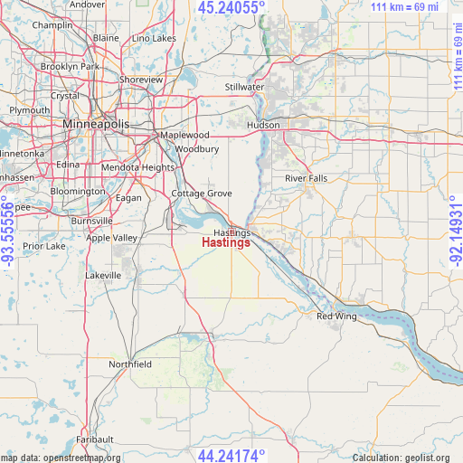
Hastings GPS coordinates[2]
44° 44' 35.88" North, 92° 51' 8.748" West
| Map corner | latitude | longitude |
|---|---|---|
| Upper-left | 45.24055°, | -93.55556° |
| Center: | 44.7433°, | -92.85243° |
| Lower-right: | 44.24174°, | -92.14931° |
| Map W x H: | 111.1×111.1 km | = 69×69mi |
| max Lat: | 71.29058° ⇑8.6% North |
| Hastings: | 44.7433° |
| min Lat: | ⇓91.4% South 19.06759° |
| min Long | Hastings | max Long |
| -171.73463° | -92.85243° | -66.98998° |
| W 34%⇐ | ⇒66% E |
Elevation
Elevation of Hastings is 218 m = 715 ft, and this is 76.8 m = 252 ft below average elevation for this country.
| Max E: |
3189 m = 10463 ft | 45.1% |
| Avg. | 294.8 m = 967 ft | |
| Hastings | 218 m = 715 ft | |
Min E: |
-60 m = -197 ft | 54.9% |
See also: United States elevation on elevation.city.
Geographical zone
Hastings is located in North temperate zone (between Tropic of Cancer and the Arctic Circle). Distance of this Northern Tropic circle is 2369.1 km =1472.1 mi to South.| Distance of | km | miles | from Hastings |
|---|---|---|---|
| North Pole | 5032.1 | 3126.8 | to North |
| Arctic Circle | 2426.2 | 1507.6 | to North |
| Tropic Cancer | 2369.1 | 1472.1 | to South |
| Equator | 4975 | 3091.3 | to South |


Nearby cities:
15 places around Hastings: (largest is in red/bold)
• Afton
18.5 km =11.5 mi,  17°
17°
• Cottage Grove
11.8 km =7.3 mi,  322°
322°
• Hampton
18.9 km =11.7 mi,  218°
218°
• Inver Grove Heights
19 km =11.8 mi,  307°
307°
• Lake Saint Croix Beach
20.9 km =13 mi, 18°
• Lakeland
24.7 km =15.3 mi, 16°
• Landfall
25.1 km =15.6 mi,  337°
337°
• Newport
18 km =11.2 mi, 319°
• Prescott
4 km =2.5 mi,  81°
81°
• River Falls
22.3 km =13.9 mi,  53°
53°
• Rosemount
21.6 km =13.4 mi,  268°
268°
• Saint Paul Park
15.5 km =9.6 mi, 315°
• South Saint Paul
22 km =13.7 mi, 319°
• Sunfish Lake
24 km =14.9 mi, 306°
• Woodbury
21.8 km =13.5 mi, 337°
Sources, notices
• [Note1] Compared only with cities in United States existing in our database
• [Src1] Map data: © OpenStreetMap contributors (CC-BY-SA)
• [Src2] Other city data from geonames.org with taken over terms of usage.
• [Src3] Geographical zone / Annual Mean Temperature by Robert A. Rohde @ Wikipedia
