Rosemount geodata
Rosemount (Minnesota) is a populated place; located in United States in America/Chicago (GMT-5) time zone. With population of 23,413 people, there are 2157 cities with bigger population in this country. Compared to other cities in United States, 91.4% of cities are located further ↓South; 66.5% of cities are located further →East and 71.1% of cities have lower elevation than Rosemount. Note1


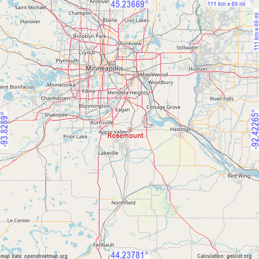
Rosemount GPS coordinates[2]
44° 44' 21.876" North, 93° 7' 32.772" West
| Map corner | latitude | longitude |
|---|---|---|
| Upper-left | 45.23669°, | -93.8289° |
| Center: | 44.73941°, | -93.12577° |
| Lower-right: | 44.23781°, | -92.42265° |
| Map W x H: | 111.1×111.1 km | = 69×69mi |
| max Lat: | 71.29058° ⇑8.6% North |
| Rosemount: | 44.73941° |
| min Lat: | ⇓91.4% South 19.06759° |
| min Long | Rosemount | max Long |
| -171.73463° | -93.12577° | -66.98998° |
| W 33.5%⇐ | ⇒66.5% E |
Elevation
Elevation of Rosemount is 291 m = 955 ft, and this is 3.8 m = 12 ft below average elevation for this country.
| Max E: |
3189 m = 10463 ft | 28.9% |
| Avg. | 294.8 m = 967 ft | |
| Rosemount | 291 m = 955 ft | |
Min E: |
-60 m = -197 ft | 71.1% |
See also: United States elevation on elevation.city.
Geographical zone
Rosemount is located in North temperate zone (between Tropic of Cancer and the Arctic Circle). Distance of this Northern Tropic circle is 2368.6 km =1471.8 mi to South.| Distance of | km | miles | from Rosemount |
|---|---|---|---|
| North Pole | 5032.5 | 3127 | to North |
| Arctic Circle | 2426.6 | 1507.8 | to North |
| Tropic Cancer | 2368.6 | 1471.8 | to South |
| Equator | 4974.6 | 3091.1 | to South |


Nearby cities:
15 places around Rosemount: (largest is in red/bold)
• Apple Valley
7.3 km =4.5 mi,  263°
263°
• Bloomington
17.7 km =11 mi,  309°
309°
• Burnsville
12.4 km =7.7 mi,  284°
284°
• Cottage Grove
17.4 km =10.8 mi,  55°
55°
• Eagan
7.9 km =4.9 mi,  335°
335°
• Farmington
11.1 km =6.9 mi,  187°
187°
• Hampton
17.4 km =10.8 mi,  145°
145°
• Inver Grove Heights
13.7 km =8.5 mi,  28°
28°
• Lakeville
13.6 km =8.5 mi,  222°
222°
• Mendota Heights
16.1 km =10 mi,  356°
356°
• Newport
17.2 km =10.7 mi, 34°
• Saint Paul Park
15.6 km =9.7 mi,  42°
42°
• Savage
17.2 km =10.7 mi, 284°
• South Saint Paul
18.5 km =11.5 mi,  22°
22°
• Sunfish Lake
14.8 km =9.2 mi,  8°
8°
Sources, notices
• [Note1] Compared only with cities in United States existing in our database
• [Src1] Map data: © OpenStreetMap contributors (CC-BY-SA)
• [Src2] Other city data from geonames.org with taken over terms of usage.
• [Src3] Geographical zone / Annual Mean Temperature by Robert A. Rohde @ Wikipedia
