Karlstad geodata
Karlstad (Minnesota) is a populated place; located in United States in America/Chicago (GMT-5) time zone. With population of 733 people, there are 18376 cities with bigger population in this country. Compared to other cities in United States, 99.2% of cities are located further ↓South; 74.5% of cities are located further →East and 75.7% of cities have lower elevation than Karlstad. Note1


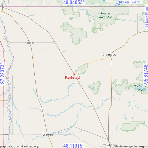
Karlstad GPS coordinates[2]
48° 34' 38.928" North, 96° 31' 14.16" West
| Map corner | latitude | longitude |
|---|---|---|
| Upper-left | 49.04053°, | -97.22373° |
| Center: | 48.57748°, | -96.5206° |
| Lower-right: | 48.11015°, | -95.81748° |
| Map W x H: | 103.4×103.4 km | = 64.2×64.2mi |
| max Lat: | 71.29058° ⇑0.8% North |
| Karlstad: | 48.57748° |
| min Lat: | ⇓99.2% South 19.06759° |
| min Long | Karlstad | max Long |
| -171.73463° | -96.5206° | -66.98998° |
| W 25.5%⇐ | ⇒74.5% E |
Elevation
Elevation of Karlstad is 318 m = 1043 ft, and this is 23.2 m = 76 ft above average elevation for this country.
| Max E: |
3189 m = 10463 ft | 24.3% |
| Karlstad | 318 m 1043 ft | |
| Avg. | 294.8 m = 967 ft | |
Min E: |
-60 m = -197 ft | 75.7% |
See also: United States elevation on elevation.city.
Geographical zone
Karlstad is located in North temperate zone (between Tropic of Cancer and the Arctic Circle). Distance of this North polar circle is 1999.9 km =1242.7 mi to North.| Distance of | km | miles | from Karlstad |
|---|---|---|---|
| North Pole | 4605.8 | 2861.9 | to North |
| Arctic Circle | 1999.9 | 1242.7 | to North |
| Tropic Cancer | 2795.4 | 1737 | to South |
| Equator | 5401.3 | 3356.2 | to South |


Nearby cities:
15 places around Karlstad: (largest is in red/bold)
• Argyle
35.1 km =21.8 mi,  219°
219°
• Cavalier
84.4 km =52.4 mi,  286°
286°
• Drayton
48.4 km =30.1 mi,  269°
269°
• East Grand Forks
81.1 km =50.4 mi,  207°
207°
• Grafton
68.1 km =42.3 mi,  254°
254°
• Grand Forks
81.8 km =50.8 mi, 207°
• Greenbush
28.4 km =17.6 mi,  61°
61°
• Hallock
38.2 km =23.7 mi,  305°
305°
• Minto
70.4 km =43.7 mi,  243°
243°
• Pembina
68.4 km =42.5 mi, 309°
• Red Lake Falls
79.4 km =49.3 mi,  166°
166°
• Roseau
63.1 km =39.2 mi, 61°
• Stephen
29.5 km =18.3 mi, 241°
• Thief River Falls
56.8 km =35.3 mi,  153°
153°
• Warren
46.3 km =28.8 mi,  203°
203°
Sources, notices
• [Note1] Compared only with cities in United States existing in our database
• [Src1] Map data: © OpenStreetMap contributors (CC-BY-SA)
• [Src2] Other city data from geonames.org with taken over terms of usage.
• [Src3] Geographical zone / Annual Mean Temperature by Robert A. Rohde @ Wikipedia
