Minto geodata
Minto (North Dakota) is a populated place; located in United States in America/Chicago (GMT-5) time zone. With population of 610 people, there are 19583 cities with bigger population in this country. Compared to other cities in United States, 98.9% of cities are located further ↓South; 76.8% of cities are located further →East and 61.9% of cities have lower elevation than Minto. Note1


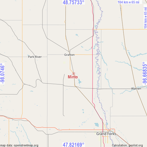
Minto GPS coordinates[2]
48° 17' 29.94" North, 97° 22' 17.292" West
| Map corner | latitude | longitude |
|---|---|---|
| Upper-left | 48.75733°, | -98.0746° |
| Center: | 48.29165°, | -97.37147° |
| Lower-right: | 47.82169°, | -96.66835° |
| Map W x H: | 104×104 km | = 64.6×64.6mi |
| max Lat: | 71.29058° ⇑1.1% North |
| Minto: | 48.29165° |
| min Lat: | ⇓98.9% South 19.06759° |
| min Long | Minto | max Long |
| -171.73463° | -97.37147° | -66.98998° |
| W 23.2%⇐ | ⇒76.8% E |
Elevation
Elevation of Minto is 248 m = 814 ft, and this is 46.8 m = 154 ft below average elevation for this country.
| Max E: |
3189 m = 10463 ft | 38.1% |
| Avg. | 294.8 m = 967 ft | |
| Minto | 248 m = 814 ft | |
Min E: |
-60 m = -197 ft | 61.9% |
See also: United States elevation on elevation.city.
Geographical zone
Minto is located in North temperate zone (between Tropic of Cancer and the Arctic Circle). Distance of this North polar circle is 2031.6 km =1262.4 mi to North.| Distance of | km | miles | from Minto |
|---|---|---|---|
| North Pole | 4637.5 | 2881.6 | to North |
| Arctic Circle | 2031.6 | 1262.4 | to North |
| Tropic Cancer | 2763.6 | 1717.2 | to South |
| Equator | 5369.5 | 3336.5 | to South |


Nearby cities:
15 places around Minto: (largest is in red/bold)
• Argyle
41 km =25.5 mi,  83°
83°
• Cavalier
58.8 km =36.5 mi,  341°
341°
• Drayton
34.2 km =21.3 mi,  24°
24°
• East Grand Forks
47.8 km =29.7 mi,  147°
147°
• Grafton
13.7 km =8.5 mi,  347°
347°
• Grand Forks
47.9 km =29.8 mi, 148°
• Grand Forks Air Force Base
37.5 km =23.3 mi,  181°
181°
• Hallock
62.1 km =38.6 mi,  30°
30°
• Karlstad
70.4 km =43.7 mi,  63°
63°
• Larimore
46.8 km =29.1 mi,  203°
203°
• Northwood
63.7 km =39.6 mi,  193°
193°
• Park River
29.8 km =18.5 mi,  293°
293°
• Stephen
40.8 km =25.4 mi, 64°
• Thompson
60.8 km =37.8 mi,  161°
161°
• Warren
45.6 km =28.3 mi,  103°
103°
Sources, notices
• [Note1] Compared only with cities in United States existing in our database
• [Src1] Map data: © OpenStreetMap contributors (CC-BY-SA)
• [Src2] Other city data from geonames.org with taken over terms of usage.
• [Src3] Geographical zone / Annual Mean Temperature by Robert A. Rohde @ Wikipedia
