Red Lake Falls geodata
Red Lake Falls (Minnesota) is a seat of a second-order administrative division; located in United States in America/Chicago (GMT-5) time zone. With population of 1,406 people, there are 14083 cities with bigger population in this country. Compared to other cities in United States, 98.4% of cities are located further ↓South; 74% of cities are located further →East and 74.7% of cities have lower elevation than Red Lake Falls. Note1
Administrative division(s):
- Level 1: Minnesota
- Level 2: Red Lake County
- Level 3: City of Red Lake Falls


Red Lake Falls GPS coordinates[2]
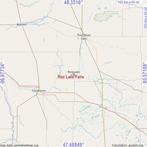
47° 52' 55.884" North, 96° 16' 27.156" West
| Map corner | latitude | longitude |
|---|---|---|
| Upper-left | 48.3516°, | -96.97734° |
| Center: | 47.88219°, | -96.27421° |
| Lower-right: | 47.40849°, | -95.57109° |
| Map W x H: | 104.9×104.9 km | = 65.2×65.2mi |
| max Lat: | 71.29058° ⇑1.6% North |
| Red Lake Falls: | 47.88219° |
| min Lat: | ⇓98.4% South 19.06759° |
| min Long | Red Lake Falls | max Long |
| -171.73463° | -96.27421° | -66.98998° |
| W 26%⇐ | ⇒74% E |
Elevation
Elevation of Red Lake Falls is 311 m = 1020 ft, and this is 16.2 m = 53 ft above average elevation for this country.
| Max E: |
3189 m = 10463 ft | 25.3% |
| Red Lake Falls | 311 m 1020 ft | |
| Avg. | 294.8 m = 967 ft | |
Min E: |
-60 m = -197 ft | 74.7% |
See also: United States elevation on elevation.city.
Geographical zone
Red Lake Falls is located in North temperate zone (between Tropic of Cancer and the Arctic Circle). Distance of this North polar circle is 2077.2 km =1290.7 mi to North.| Distance of | km | miles | from Red Lake Falls |
|---|---|---|---|
| North Pole | 4683.1 | 2909.9 | to North |
| Arctic Circle | 2077.2 | 1290.7 | to North |
| Tropic Cancer | 2718.1 | 1688.9 | to South |
| Equator | 5324 | 3308.2 | to South |


Nearby cities:
15 places around Red Lake Falls: (largest is in red/bold)
• Ada
67.2 km =41.8 mi,  195°
195°
• Argyle
64.5 km =40.1 mi,  320°
320°
• Clearbrook
66.4 km =41.3 mi,  108°
108°
• Crookston
27.7 km =17.2 mi,  244°
244°
• East Grand Forks
56.2 km =34.9 mi,  275°
275°
• Fertile
38.5 km =23.9 mi,  180°
180°
• Fosston
51.8 km =32.2 mi,  131°
131°
• Grand Forks
56.8 km =35.3 mi,  274°
274°
• Halstad
72.2 km =44.9 mi,  215°
215°
• Mahnomen
67.1 km =41.7 mi,  160°
160°
• McIntosh
39.8 km =24.7 mi, 133°
• Thief River Falls
27.2 km =16.9 mi,  14°
14°
• Thompson
63.5 km =39.5 mi,  259°
259°
• Twin Valley
69.2 km =43 mi, 179°
• Warren
51 km =31.7 mi,  313°
313°
Sources, notices
• [Note1] Compared only with cities in United States existing in our database
• [Src1] Map data: © OpenStreetMap contributors (CC-BY-SA)
• [Src2] Other city data from geonames.org with taken over terms of usage.
• [Src3] Geographical zone / Annual Mean Temperature by Robert A. Rohde @ Wikipedia
