Thief River Falls geodata
Thief River Falls (Minnesota) is a seat of a second-order administrative division; located in United States in America/Chicago (GMT-5) time zone. With population of 8,752 people, there are 4906 cities with bigger population in this country. Compared to other cities in United States, 98.8% of cities are located further ↓South; 73.8% of cities are located further →East and 79.1% of cities have lower elevation than Thief River Falls. Note1
Administrative division(s):
- Level 1: Minnesota
- Level 2: Pennington County
- Level 3: City of Thief River Falls


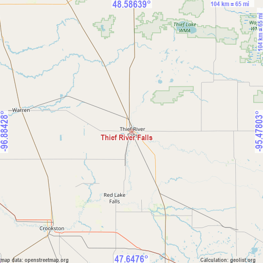
Thief River Falls GPS coordinates[2]
48° 7' 8.904" North, 96° 10' 52.14" West
| Map corner | latitude | longitude |
|---|---|---|
| Upper-left | 48.58639°, | -96.88428° |
| Center: | 48.11914°, | -96.18115° |
| Lower-right: | 47.6476°, | -95.47803° |
| Map W x H: | 104.4×104.4 km | = 64.9×64.9mi |
| max Lat: | 71.29058° ⇑1.2% North |
| Thief River Falls: | 48.11914° |
| min Lat: | ⇓98.8% South 19.06759° |
| min Long | Thief River Fal | max Long |
| -171.73463° | -96.18115° | -66.98998° |
| W 26.2%⇐ | ⇒73.8% E |
Elevation
Elevation of Thief River Falls is 345 m = 1132 ft, and this is 50.2 m = 165 ft above average elevation for this country.
| Max E: |
3189 m = 10463 ft | 20.9% |
| Thief River Falls | 345 m 1132 ft | |
| Avg. | 294.8 m = 967 ft | |
Min E: |
-60 m = -197 ft | 79.1% |
See also: United States elevation on elevation.city.
Geographical zone
Thief River Falls is located in North temperate zone (between Tropic of Cancer and the Arctic Circle). Distance of this North polar circle is 2050.8 km =1274.3 mi to North.| Distance of | km | miles | from Thief River Falls |
|---|---|---|---|
| North Pole | 4656.7 | 2893.5 | to North |
| Arctic Circle | 2050.8 | 1274.3 | to North |
| Tropic Cancer | 2744.4 | 1705.3 | to South |
| Equator | 5350.3 | 3324.5 | to South |


Nearby cities:
15 places around Thief River Falls: (largest is in red/bold)
• Argyle
53 km =32.9 mi,  296°
296°
• Clearbrook
73.4 km =45.6 mi,  130°
130°
• Crookston
49.8 km =30.9 mi,  219°
219°
• East Grand Forks
66.1 km =41.1 mi,  251°
251°
• Fertile
65.3 km =40.6 mi,  186°
186°
• Fosston
68.3 km =42.4 mi,  152°
152°
• Grand Forks
66.9 km =41.6 mi, 251°
• Greenbush
64.6 km =40.1 mi,  359°
359°
• Karlstad
56.8 km =35.3 mi,  333°
333°
• Little Rock
84.4 km =52.4 mi,  109°
109°
• McIntosh
57.9 km =36 mi,  157°
157°
• Red Lake Falls
27.2 km =16.9 mi, 194°
• Stephen
63 km =39.1 mi,  305°
305°
• Thompson
79.1 km =49.2 mi,  240°
240°
• Warren
44.7 km =27.8 mi,  281°
281°
Sources, notices
• [Note1] Compared only with cities in United States existing in our database
• [Src1] Map data: © OpenStreetMap contributors (CC-BY-SA)
• [Src2] Other city data from geonames.org with taken over terms of usage.
• [Src3] Geographical zone / Annual Mean Temperature by Robert A. Rohde @ Wikipedia
