Wadena geodata
Wadena (Minnesota) is a seat of a second-order administrative division; located in United States in America/Chicago (GMT-5) time zone. With population of 4,176 people, there are 8020 cities with bigger population in this country. Compared to other cities in United States, 95.7% of cities are located further ↓South; 71.5% of cities are located further →East and 84.4% of cities have lower elevation than Wadena. Note1


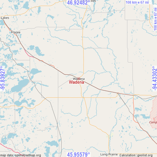
Wadena GPS coordinates[2]
46° 26' 32.856" North, 95° 8' 10.104" West
| Map corner | latitude | longitude |
|---|---|---|
| Upper-left | 46.92482°, | -95.83927° |
| Center: | 46.44246°, | -95.13614° |
| Lower-right: | 45.95579°, | -94.43302° |
| Map W x H: | 107.7×107.7 km | = 66.9×66.9mi |
| max Lat: | 71.29058° ⇑4.3% North |
| Wadena: | 46.44246° |
| min Lat: | ⇓95.7% South 19.06759° |
| min Long | Wadena | max Long |
| -171.73463° | -95.13614° | -66.98998° |
| W 28.5%⇐ | ⇒71.5% E |
Elevation
Elevation of Wadena is 412 m = 1352 ft, and this is 117.2 m = 385 ft above average elevation for this country.
| Max E: |
3189 m = 10463 ft | 15.6% |
| Wadena | 412 m 1352 ft | |
| Avg. | 294.8 m = 967 ft | |
Min E: |
-60 m = -197 ft | 84.4% |
See also: United States elevation on elevation.city.
Geographical zone
Wadena is located in North temperate zone (between Tropic of Cancer and the Arctic Circle). Distance of this North polar circle is 2237.3 km =1390.2 mi to North.| Distance of | km | miles | from Wadena |
|---|---|---|---|
| North Pole | 4843.1 | 3009.4 | to North |
| Arctic Circle | 2237.3 | 1390.2 | to North |
| Tropic Cancer | 2558 | 1589.5 | to South |
| Equator | 5163.9 | 3208.7 | to South |


Nearby cities:
15 places around Wadena: (largest is in red/bold)
• Battle Lake
47.8 km =29.7 mi,  247°
247°
• Browerville
44.8 km =27.8 mi,  152°
152°
• Clarissa
37.6 km =23.4 mi,  157°
157°
• Eagle Bend
31.7 km =19.7 mi,  166°
166°
• Frazee
53.6 km =33.3 mi,  306°
306°
• Henning
27.3 km =17 mi,  240°
240°
• Menahga
34.7 km =21.6 mi,  4°
4°
• Motley
39.4 km =24.5 mi,  107°
107°
• New York Mills
20.2 km =12.6 mi,  294°
294°
• Ottertail
32.3 km =20.1 mi,  266°
266°
• Parkers Prairie
35.4 km =22 mi,  204°
204°
• Perham
37.4 km =23.2 mi,  296°
296°
• Sebeka
21.2 km =13.2 mi,  9°
9°
• Staples
28.1 km =17.5 mi, 110°
• Verndale
10.5 km =6.5 mi,  117°
117°
Sources, notices
• [Note1] Compared only with cities in United States existing in our database
• [Src1] Map data: © OpenStreetMap contributors (CC-BY-SA)
• [Src2] Other city data from geonames.org with taken over terms of usage.
• [Src3] Geographical zone / Annual Mean Temperature by Robert A. Rohde @ Wikipedia
