Oakes geodata
Oakes (North Dakota) is a populated place; located in United States in America/Chicago (GMT-5) time zone. With population of 1,797 people, there are 12550 cities with bigger population in this country. Compared to other cities in United States, 95.3% of cities are located further ↓South; 78.7% of cities are located further →East and 83.8% of cities have lower elevation than Oakes. Note1


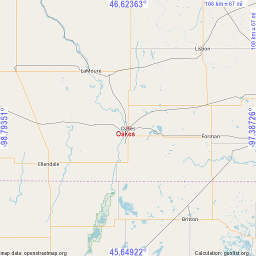
Oakes GPS coordinates[2]
46° 8' 18.888" North, 98° 5' 25.368" West
| Map corner | latitude | longitude |
|---|---|---|
| Upper-left | 46.62363°, | -98.79351° |
| Center: | 46.13858°, | -98.09038° |
| Lower-right: | 45.64922°, | -97.38726° |
| Map W x H: | 108.3×108.3 km | = 67.3×67.3mi |
| max Lat: | 71.29058° ⇑4.7% North |
| Oakes: | 46.13858° |
| min Lat: | ⇓95.3% South 19.06759° |
| min Long | Oakes | max Long |
| -171.73463° | -98.09038° | -66.98998° |
| W 21.3%⇐ | ⇒78.7% E |
Elevation
Elevation of Oakes is 401 m = 1316 ft, and this is 106.2 m = 348 ft above average elevation for this country.
| Max E: |
3189 m = 10463 ft | 16.2% |
| Oakes | 401 m 1316 ft | |
| Avg. | 294.8 m = 967 ft | |
Min E: |
-60 m = -197 ft | 83.8% |
See also: United States elevation on elevation.city.
Geographical zone
Oakes is located in North temperate zone (between Tropic of Cancer and the Arctic Circle). Distance of this North polar circle is 2271 km =1411.1 mi to North.| Distance of | km | miles | from Oakes |
|---|---|---|---|
| North Pole | 4876.9 | 3030.4 | to North |
| Arctic Circle | 2271 | 1411.1 | to North |
| Tropic Cancer | 2524.2 | 1568.5 | to South |
| Equator | 5130.1 | 3187.7 | to South |


Nearby cities:
15 places around Oakes: (largest is in red/bold)
• Aberdeen
81 km =50.3 mi,  202°
202°
• Britton
46.7 km =29 mi,  145°
145°
• Edgeley
54 km =33.6 mi,  297°
297°
• Ellendale
36.9 km =22.9 mi,  245°
245°
• Enderlin
65.6 km =40.8 mi,  34°
34°
• Forman
35.1 km =21.8 mi,  95°
95°
• Groton
76.8 km =47.7 mi,  180°
180°
• Gwinner
34.3 km =21.3 mi,  73°
73°
• LaMoure
28.9 km =18 mi,  327°
327°
• Leola
80.4 km =50 mi,  234°
234°
• Lidgerwood
72.7 km =45.2 mi, 95°
• Lisbon
46.1 km =28.6 mi,  43°
43°
• Milnor
50.6 km =31.4 mi, 74°
• Sheldon
67.7 km =42.1 mi, 42°
• Veblen
69.2 km =43 mi,  116°
116°
Sources, notices
• [Note1] Compared only with cities in United States existing in our database
• [Src1] Map data: © OpenStreetMap contributors (CC-BY-SA)
• [Src2] Other city data from geonames.org with taken over terms of usage.
• [Src3] Geographical zone / Annual Mean Temperature by Robert A. Rohde @ Wikipedia
