Britton geodata
Britton (South Dakota) is a seat of a second-order administrative division; located in United States in America/Chicago (GMT-5) time zone. With population of 1,242 people, there are 14897 cities with bigger population in this country. Compared to other cities in United States, 94.7% of cities are located further ↓South; 77.9% of cities are located further →East and 84.5% of cities have lower elevation than Britton. Note1


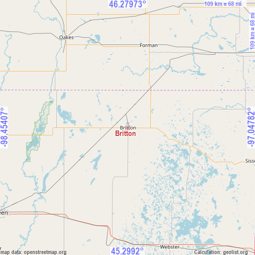
Britton GPS coordinates[2]
45° 47' 29.832" North, 97° 45' 3.384" West
| Map corner | latitude | longitude |
|---|---|---|
| Upper-left | 46.27973°, | -98.45407° |
| Center: | 45.79162°, | -97.75094° |
| Lower-right: | 45.2992°, | -97.04782° |
| Map W x H: | 109×109 km | = 67.7×67.7mi |
| max Lat: | 71.29058° ⇑5.3% North |
| Britton: | 45.79162° |
| min Lat: | ⇓94.7% South 19.06759° |
| min Long | Britton | max Long |
| -171.73463° | -97.75094° | -66.98998° |
| W 22.1%⇐ | ⇒77.9% E |
Elevation
Elevation of Britton is 414 m = 1358 ft, and this is 119.2 m = 391 ft above average elevation for this country.
| Max E: |
3189 m = 10463 ft | 15.5% |
| Britton | 414 m 1358 ft | |
| Avg. | 294.8 m = 967 ft | |
Min E: |
-60 m = -197 ft | 84.5% |
See also: United States elevation on elevation.city.
Geographical zone
Britton is located in North temperate zone (between Tropic of Cancer and the Arctic Circle). Distance of this North polar circle is 2309.6 km =1435.1 mi to North.| Distance of | km | miles | from Britton |
|---|---|---|---|
| North Pole | 4915.5 | 3054.3 | to North |
| Arctic Circle | 2309.6 | 1435.1 | to North |
| Tropic Cancer | 2485.6 | 1544.5 | to South |
| Equator | 5091.6 | 3163.8 | to South |


Nearby cities:
15 places around Britton: (largest is in red/bold)
• Aberdeen
67.8 km =42.1 mi,  237°
237°
• Ellendale
64.5 km =40.1 mi,  291°
291°
• Forman
36.2 km =22.5 mi,  14°
14°
• Goodwill
58.5 km =36.4 mi,  115°
115°
• Groton
46.9 km =29.1 mi,  215°
215°
• Gwinner
48.8 km =30.3 mi, 8°
• Hankinson
72.6 km =45.1 mi,  64°
64°
• Lidgerwood
56.1 km =34.9 mi, 55°
• Lisbon
72.5 km =45 mi,  4°
4°
• Milnor
56.7 km =35.2 mi,  23°
23°
• Oakes
46.7 km =29 mi,  325°
325°
• Sisseton
56.2 km =34.9 mi,  104°
104°
• Veblen
36.8 km =22.9 mi,  77°
77°
• Waubay
61.8 km =38.4 mi,  145°
145°
• Webster
54.2 km =33.7 mi,  160°
160°
Sources, notices
• [Note1] Compared only with cities in United States existing in our database
• [Src1] Map data: © OpenStreetMap contributors (CC-BY-SA)
• [Src2] Other city data from geonames.org with taken over terms of usage.
• [Src3] Geographical zone / Annual Mean Temperature by Robert A. Rohde @ Wikipedia
