Groton geodata
Groton (South Dakota) is a populated place; located in United States in America/Chicago (GMT-5) time zone. With population of 1,508 people, there are 13621 cities with bigger population in this country. Compared to other cities in United States, 93.9% of cities are located further ↓South; 78.7% of cities are located further →East and 83.5% of cities have lower elevation than Groton. Note1


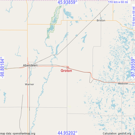
Groton GPS coordinates[2]
45° 26' 50.856" North, 98° 5' 55.356" West
| Map corner | latitude | longitude |
|---|---|---|
| Upper-left | 45.93859°, | -98.80184° |
| Center: | 45.44746°, | -98.09871° |
| Lower-right: | 44.95202°, | -97.39559° |
| Map W x H: | 109.7×109.7 km | = 68.2×68.2mi |
| max Lat: | 71.29058° ⇑6.1% North |
| Groton: | 45.44746° |
| min Lat: | ⇓93.9% South 19.06759° |
| min Long | Groton | max Long |
| -171.73463° | -98.09871° | -66.98998° |
| W 21.3%⇐ | ⇒78.7% E |
Elevation
Elevation of Groton is 397 m = 1302 ft, and this is 102.2 m = 335 ft above average elevation for this country.
| Max E: |
3189 m = 10463 ft | 16.5% |
| Groton | 397 m 1302 ft | |
| Avg. | 294.8 m = 967 ft | |
Min E: |
-60 m = -197 ft | 83.5% |
See also: United States elevation on elevation.city.
Geographical zone
Groton is located in North temperate zone (between Tropic of Cancer and the Arctic Circle). Distance of this North polar circle is 2347.9 km =1458.9 mi to North.| Distance of | km | miles | from Groton |
|---|---|---|---|
| North Pole | 4953.8 | 3078.1 | to North |
| Arctic Circle | 2347.9 | 1458.9 | to North |
| Tropic Cancer | 2447.4 | 1520.7 | to South |
| Equator | 5053.3 | 3140 | to South |


Nearby cities:
15 places around Groton: (largest is in red/bold)
• Aberdeen
30.3 km =18.8 mi,  273°
273°
• Britton
46.9 km =29.1 mi,  35°
35°
• Clark
69.5 km =43.2 mi,  155°
155°
• Ellendale
70.1 km =43.6 mi,  331°
331°
• Faulkton
92.4 km =57.4 mi,  240°
240°
• Forman
81.7 km =50.8 mi,  26°
26°
• Goodwill
81.2 km =50.5 mi,  80°
80°
• Ipswich
72.6 km =45.1 mi, 269°
• Leola
72.3 km =44.9 mi,  295°
295°
• Oakes
76.8 km =47.7 mi,  0°
0°
• Redfield
71.6 km =44.5 mi,  207°
207°
• Sisseton
85.2 km =52.9 mi,  73°
73°
• Veblen
78.2 km =48.6 mi,  53°
53°
• Waubay
63.3 km =39.3 mi,  101°
101°
• Webster
47 km =29.2 mi,  105°
105°
Sources, notices
• [Note1] Compared only with cities in United States existing in our database
• [Src1] Map data: © OpenStreetMap contributors (CC-BY-SA)
• [Src2] Other city data from geonames.org with taken over terms of usage.
• [Src3] Geographical zone / Annual Mean Temperature by Robert A. Rohde @ Wikipedia
