Beemer geodata
Beemer (Nebraska) is a populated place; located in United States in America/Chicago (GMT-5) time zone. With population of 671 people, there are 18962 cities with bigger population in this country. Compared to other cities in United States, 75.1% of cities are located further ↓South; 75.2% of cities are located further →East and 84.5% of cities have lower elevation than Beemer. Note1


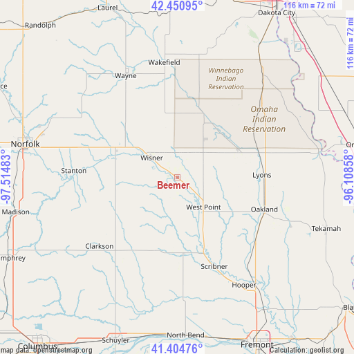
Beemer GPS coordinates[2]
41° 55' 48" North, 96° 48' 42.12" West
| Map corner | latitude | longitude |
|---|---|---|
| Upper-left | 42.45095°, | -97.51483° |
| Center: | 41.93°, | -96.8117° |
| Lower-right: | 41.40476°, | -96.10858° |
| Map W x H: | 116.3×116.3 km | = 72.3×72.3mi |
| max Lat: | 71.29058° ⇑24.9% North |
| Beemer: | 41.93° |
| min Lat: | ⇓75.1% South 19.06759° |
| min Long | Beemer | max Long |
| -171.73463° | -96.8117° | -66.98998° |
| W 24.8%⇐ | ⇒75.2% E |
Elevation
Elevation of Beemer is 413 m = 1355 ft, and this is 118.2 m = 388 ft above average elevation for this country.
| Max E: |
3189 m = 10463 ft | 15.5% |
| Beemer | 413 m 1355 ft | |
| Avg. | 294.8 m = 967 ft | |
Min E: |
-60 m = -197 ft | 84.5% |
See also: United States elevation on elevation.city.
Geographical zone
Beemer is located in North temperate zone (between Tropic of Cancer and the Arctic Circle). Distance of this Northern Tropic circle is 2056.3 km =1277.7 mi to South.| Distance of | km | miles | from Beemer |
|---|---|---|---|
| North Pole | 5344.9 | 3321.2 | to North |
| Arctic Circle | 2739 | 1701.9 | to North |
| Tropic Cancer | 2056.3 | 1277.7 | to South |
| Equator | 4662.2 | 2897 | to South |


Nearby cities:
15 places around Beemer: (largest is in red/bold)
• Clarkson
34.3 km =21.3 mi,  228°
228°
• Dodge
24 km =14.9 mi,  194°
194°
• Emerson
39.4 km =24.5 mi,  10°
10°
• Hooper
41.7 km =25.9 mi,  148°
148°
• Howells
27.8 km =17.3 mi,  214°
214°
• Lyons
27.7 km =17.2 mi,  88°
88°
• Oakland
30.4 km =18.9 mi,  110°
110°
• Pender
22.2 km =13.8 mi,  22°
22°
• Scribner
31.7 km =19.7 mi,  157°
157°
• Stanton
34.2 km =21.3 mi,  273°
273°
• Wakefield
38 km =23.6 mi,  353°
353°
• Walthill
36.1 km =22.4 mi,  47°
47°
• Wayne
37.5 km =23.3 mi,  333°
333°
• West Point
13 km =8.1 mi,  139°
139°
• Wisner
10.6 km =6.6 mi,  306°
306°
Sources, notices
• [Note1] Compared only with cities in United States existing in our database
• [Src1] Map data: © OpenStreetMap contributors (CC-BY-SA)
• [Src2] Other city data from geonames.org with taken over terms of usage.
• [Src3] Geographical zone / Annual Mean Temperature by Robert A. Rohde @ Wikipedia
