Hooper geodata
Hooper (Nebraska) is a populated place; located in United States in America/Chicago (GMT-5) time zone. With population of 829 people, there are 17526 cities with bigger population in this country. Compared to other cities in United States, 72% of cities are located further ↓South; 74.6% of cities are located further →East and 81.8% of cities have lower elevation than Hooper. Note1


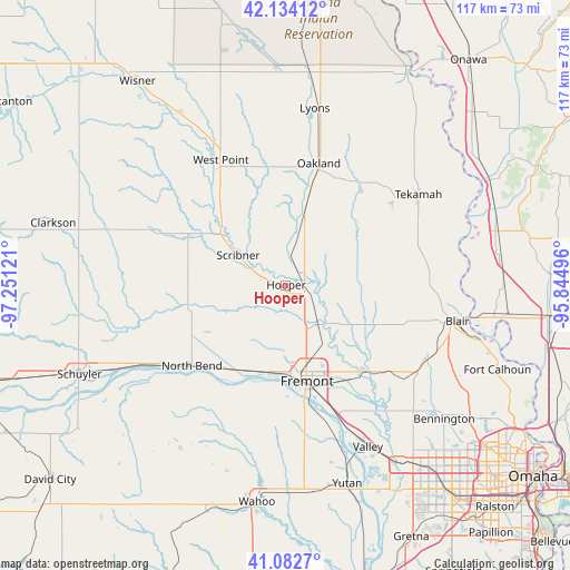
Hooper GPS coordinates[2]
41° 36' 37.98" North, 96° 32' 53.088" West
| Map corner | latitude | longitude |
|---|---|---|
| Upper-left | 42.13412°, | -97.25121° |
| Center: | 41.61055°, | -96.54808° |
| Lower-right: | 41.0827°, | -95.84496° |
| Map W x H: | 116.9×116.9 km | = 72.6×72.6mi |
| max Lat: | 71.29058° ⇑28% North |
| Hooper: | 41.61055° |
| min Lat: | ⇓72% South 19.06759° |
| min Long | Hooper | max Long |
| -171.73463° | -96.54808° | -66.98998° |
| W 25.4%⇐ | ⇒74.6% E |
Elevation
Elevation of Hooper is 374 m = 1227 ft, and this is 79.2 m = 260 ft above average elevation for this country.
| Max E: |
3189 m = 10463 ft | 18.2% |
| Hooper | 374 m 1227 ft | |
| Avg. | 294.8 m = 967 ft | |
Min E: |
-60 m = -197 ft | 81.8% |
See also: United States elevation on elevation.city.
Geographical zone
Hooper is located in North temperate zone (between Tropic of Cancer and the Arctic Circle). Distance of this Northern Tropic circle is 2020.7 km =1255.6 mi to South.| Distance of | km | miles | from Hooper |
|---|---|---|---|
| North Pole | 5380.4 | 3343.2 | to North |
| Arctic Circle | 2774.5 | 1724 | to North |
| Tropic Cancer | 2020.7 | 1255.6 | to South |
| Equator | 4626.7 | 2874.9 | to South |


Nearby cities:
15 places around Hooper: (largest is in red/bold)
• Arlington
24 km =14.9 mi,  136°
136°
• Beemer
41.7 km =25.9 mi,  328°
328°
• Blair
35.9 km =22.3 mi,  101°
101°
• Cedar Bluffs
24.3 km =15.1 mi,  192°
192°
• Dodge
30.4 km =18.9 mi,  293°
293°
• Fremont
20.1 km =12.5 mi,  168°
168°
• Howells
39.9 km =24.8 mi, 288°
• Lyons
36.8 km =22.9 mi,  9°
9°
• North Bend
25.4 km =15.8 mi,  229°
229°
• Oakland
25.9 km =16.1 mi,  15°
15°
• Scribner
11.6 km =7.2 mi,  302°
302°
• Tekamah
32.9 km =20.4 mi,  55°
55°
• Valley
37.1 km =23.1 mi,  153°
153°
• Waterloo
42.1 km =26.2 mi, 148°
• West Point
28.9 km =18 mi, 332°
Sources, notices
• [Note1] Compared only with cities in United States existing in our database
• [Src1] Map data: © OpenStreetMap contributors (CC-BY-SA)
• [Src2] Other city data from geonames.org with taken over terms of usage.
• [Src3] Geographical zone / Annual Mean Temperature by Robert A. Rohde @ Wikipedia
