Howells geodata
Howells (Nebraska) is a populated place; located in United States in America/Chicago (GMT-5) time zone. With population of 554 people, there are 20228 cities with bigger population in this country. Compared to other cities in United States, 73.2% of cities are located further ↓South; 75.7% of cities are located further →East and 86.2% of cities have lower elevation than Howells. Note1


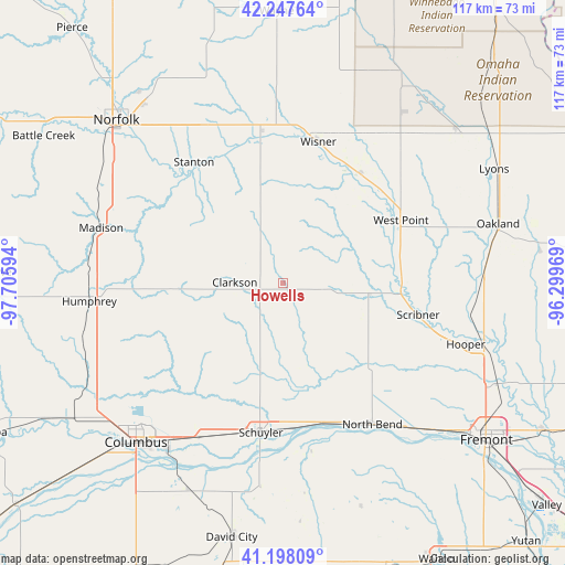
Howells GPS coordinates[2]
41° 43' 30.036" North, 97° 0' 10.116" West
| Map corner | latitude | longitude |
|---|---|---|
| Upper-left | 42.24764°, | -97.70594° |
| Center: | 41.72501°, | -97.00281° |
| Lower-right: | 41.19809°, | -96.29969° |
| Map W x H: | 116.7×116.7 km | = 72.5×72.5mi |
| max Lat: | 71.29058° ⇑26.8% North |
| Howells: | 41.72501° |
| min Lat: | ⇓73.2% South 19.06759° |
| min Long | Howells | max Long |
| -171.73463° | -97.00281° | -66.98998° |
| W 24.3%⇐ | ⇒75.7% E |
Elevation
Elevation of Howells is 447 m = 1467 ft, and this is 152.2 m = 499 ft above average elevation for this country.
| Max E: |
3189 m = 10463 ft | 13.8% |
| Howells | 447 m 1467 ft | |
| Avg. | 294.8 m = 967 ft | |
Min E: |
-60 m = -197 ft | 86.2% |
See also: United States elevation on elevation.city.
Geographical zone
Howells is located in North temperate zone (between Tropic of Cancer and the Arctic Circle). Distance of this Northern Tropic circle is 2033.5 km =1263.6 mi to South.| Distance of | km | miles | from Howells |
|---|---|---|---|
| North Pole | 5367.7 | 3335.3 | to North |
| Arctic Circle | 2761.8 | 1716.1 | to North |
| Tropic Cancer | 2033.5 | 1263.6 | to South |
| Equator | 4639.4 | 2882.8 | to South |


Nearby cities:
15 places around Howells: (largest is in red/bold)
• Beemer
27.8 km =17.3 mi,  34°
34°
• Clarkson
9.9 km =6.2 mi,  271°
271°
• Columbus
44.7 km =27.8 mi,  222°
222°
• Dodge
10 km =6.2 mi,  92°
92°
• Hooper
39.9 km =24.8 mi,  108°
108°
• Humphrey
40.2 km =25 mi,  264°
264°
• Madison
39.2 km =24.4 mi,  287°
287°
• Norfolk
48.1 km =29.9 mi,  314°
314°
• North Bend
34.6 km =21.5 mi,  147°
147°
• Oakland
46.1 km =28.6 mi,  74°
74°
• Schuyler
31.2 km =19.4 mi,  188°
188°
• Scribner
28.7 km =17.8 mi,  103°
103°
• Stanton
31 km =19.3 mi,  323°
323°
• West Point
27.6 km =17.1 mi,  61°
61°
• Wisner
30.1 km =18.7 mi,  14°
14°
Sources, notices
• [Note1] Compared only with cities in United States existing in our database
• [Src1] Map data: © OpenStreetMap contributors (CC-BY-SA)
• [Src2] Other city data from geonames.org with taken over terms of usage.
• [Src3] Geographical zone / Annual Mean Temperature by Robert A. Rohde @ Wikipedia
