Stanton geodata
Stanton (Nebraska) is a seat of a second-order administrative division; located in United States in America/Chicago (GMT-5) time zone. With population of 1,519 people, there are 13587 cities with bigger population in this country. Compared to other cities in United States, 75.2% of cities are located further ↓South; 76.4% of cities are located further →East and 86.3% of cities have lower elevation than Stanton. Note1


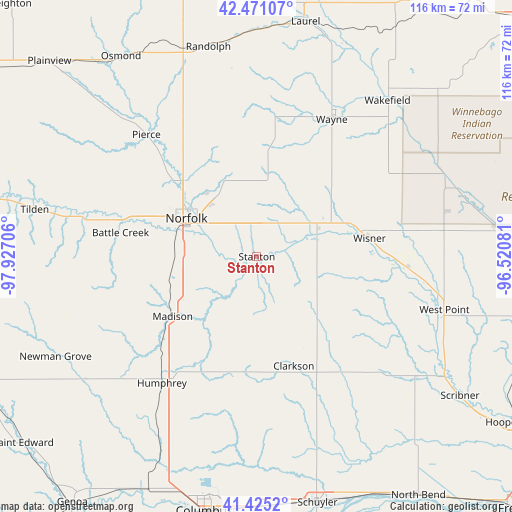
Stanton GPS coordinates[2]
41° 57' 1.008" North, 97° 13' 26.148" West
| Map corner | latitude | longitude |
|---|---|---|
| Upper-left | 42.47107°, | -97.92706° |
| Center: | 41.95028°, | -97.22393° |
| Lower-right: | 41.4252°, | -96.52081° |
| Map W x H: | 116.3×116.3 km | = 72.3×72.3mi |
| max Lat: | 71.29058° ⇑24.8% North |
| Stanton: | 41.95028° |
| min Lat: | ⇓75.2% South 19.06759° |
| min Long | Stanton | max Long |
| -171.73463° | -97.22393° | -66.98998° |
| W 23.6%⇐ | ⇒76.4% E |
Elevation
Elevation of Stanton is 450 m = 1476 ft, and this is 155.2 m = 509 ft above average elevation for this country.
| Max E: |
3189 m = 10463 ft | 13.7% |
| Stanton | 450 m 1476 ft | |
| Avg. | 294.8 m = 967 ft | |
Min E: |
-60 m = -197 ft | 86.3% |
See also: United States elevation on elevation.city.
Geographical zone
Stanton is located in North temperate zone (between Tropic of Cancer and the Arctic Circle). Distance of this Northern Tropic circle is 2058.5 km =1279.1 mi to South.| Distance of | km | miles | from Stanton |
|---|---|---|---|
| North Pole | 5342.6 | 3319.7 | to North |
| Arctic Circle | 2736.7 | 1700.5 | to North |
| Tropic Cancer | 2058.5 | 1279.1 | to South |
| Equator | 4664.4 | 2898.3 | to South |


Nearby cities:
15 places around Stanton: (largest is in red/bold)
• Battle Creek
31.4 km =19.5 mi,  280°
280°
• Beemer
34.2 km =21.3 mi,  93°
93°
• Clarkson
26.3 km =16.3 mi,  161°
161°
• Dodge
38.1 km =23.7 mi,  132°
132°
• Howells
31 km =19.3 mi,  143°
143°
• Humphrey
36 km =22.4 mi,  216°
216°
• Madison
23.4 km =14.5 mi,  234°
234°
• Norfolk
18.2 km =11.3 mi,  298°
298°
• Pender
46.4 km =28.8 mi,  66°
66°
• Pierce
37.3 km =23.2 mi,  317°
317°
• Randolph
48.9 km =30.4 mi,  347°
347°
• Wakefield
46.2 km =28.7 mi,  39°
39°
• Wayne
35.5 km =22.1 mi,  28°
28°
• West Point
44.3 km =27.5 mi,  105°
105°
• Wisner
25.9 km =16.1 mi,  80°
80°
Sources, notices
• [Note1] Compared only with cities in United States existing in our database
• [Src1] Map data: © OpenStreetMap contributors (CC-BY-SA)
• [Src2] Other city data from geonames.org with taken over terms of usage.
• [Src3] Geographical zone / Annual Mean Temperature by Robert A. Rohde @ Wikipedia
