Callaway geodata
Callaway (Nebraska) is a populated place; located in United States in America/Chicago (GMT-5) time zone. With population of 522 people, there are 20606 cities with bigger population in this country. Compared to other cities in United States, 68.7% of cities are located further ↓South; 80.7% of cities are located further →East and 91.8% of cities have lower elevation than Callaway. Note1


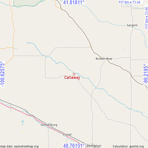
Callaway GPS coordinates[2]
41° 17' 31.02" North, 99° 55' 21.432" West
| Map corner | latitude | longitude |
|---|---|---|
| Upper-left | 41.81811°, | -100.62575° |
| Center: | 41.29195°, | -99.92262° |
| Lower-right: | 40.76151°, | -99.2195° |
| Map W x H: | 117.5×117.5 km | = 73×73mi |
| max Lat: | 71.29058° ⇑31.3% North |
| Callaway: | 41.29195° |
| min Lat: | ⇓68.7% South 19.06759° |
| min Long | Callaway | max Long |
| -171.73463° | -99.92262° | -66.98998° |
| W 19.3%⇐ | ⇒80.7% E |
Elevation
Elevation of Callaway is 783 m = 2569 ft, and this is 488.2 m = 1602 ft above average elevation for this country.
| Max E: |
3189 m = 10463 ft | 8.2% |
| Callaway | 783 m 2569 ft | |
| Avg. | 294.8 m = 967 ft | |
Min E: |
-60 m = -197 ft | 91.8% |
See also: United States elevation on elevation.city.
Geographical zone
Callaway is located in North temperate zone (between Tropic of Cancer and the Arctic Circle). Distance of this Northern Tropic circle is 1985.3 km =1233.6 mi to South.| Distance of | km | miles | from Callaway |
|---|---|---|---|
| North Pole | 5415.8 | 3365.2 | to North |
| Arctic Circle | 2809.9 | 1746 | to North |
| Tropic Cancer | 1985.3 | 1233.6 | to South |
| Equator | 4591.2 | 2852.8 | to South |


Nearby cities:
15 places around Callaway: (largest is in red/bold)
• Arnold
26.9 km =16.7 mi,  302°
302°
• Brewster
72.1 km =44.8 mi,  3°
3°
• Broken Bow
26.6 km =16.5 mi,  62°
62°
• Burwell
85.3 km =53 mi,  50°
50°
• Cozad
48.4 km =30.1 mi,  186°
186°
• Elm Creek
78.7 km =48.9 mi,  144°
144°
• Elwood
78.2 km =48.6 mi,  176°
176°
• Gothenburg
45 km =28 mi,  206°
206°
• Lexington
58.8 km =36.5 mi,  165°
165°
• Loup City
79.9 km =49.6 mi,  91°
91°
• North Platte
72.9 km =45.3 mi,  255°
255°
• Overton
69.5 km =43.2 mi,  152°
152°
• Sargent
60.1 km =37.3 mi, 49°
• Stapleton
53.5 km =33.2 mi,  293°
293°
• Taylor
69.8 km =43.4 mi,  40°
40°
Sources, notices
• [Note1] Compared only with cities in United States existing in our database
• [Src1] Map data: © OpenStreetMap contributors (CC-BY-SA)
• [Src2] Other city data from geonames.org with taken over terms of usage.
• [Src3] Geographical zone / Annual Mean Temperature by Robert A. Rohde @ Wikipedia
