Stapleton geodata
Stapleton (Nebraska) is a seat of a second-order administrative division; located in United States in America/Chicago (GMT-5) time zone. With population of 311 people, there are 20969 cities with bigger population in this country. Compared to other cities in United States, 70.6% of cities are located further ↓South; 81% of cities are located further →East and 92.6% of cities have lower elevation than Stapleton. Note1


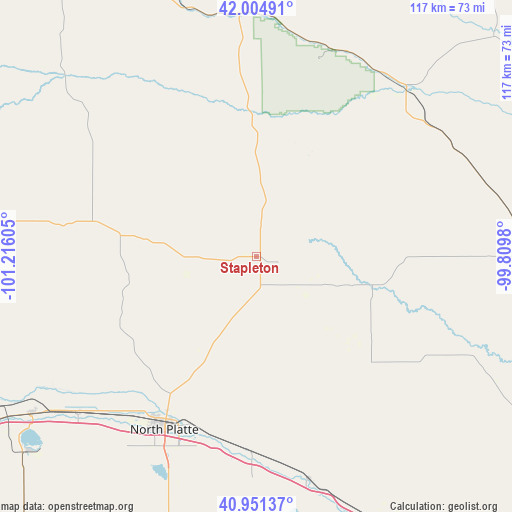
Stapleton GPS coordinates[2]
41° 28' 49.008" North, 100° 30' 46.512" West
| Map corner | latitude | longitude |
|---|---|---|
| Upper-left | 42.00491°, | -101.21605° |
| Center: | 41.48028°, | -100.51292° |
| Lower-right: | 40.95137°, | -99.8098° |
| Map W x H: | 117.1×117.1 km | = 72.8×72.8mi |
| max Lat: | 71.29058° ⇑29.4% North |
| Stapleton: | 41.48028° |
| min Lat: | ⇓70.6% South 19.06759° |
| min Long | Stapleton | max Long |
| -171.73463° | -100.51292° | -66.98998° |
| W 19%⇐ | ⇒81% E |
Elevation
Elevation of Stapleton is 885 m = 2904 ft, and this is 590.2 m = 1936 ft above average elevation for this country.
| Max E: |
3189 m = 10463 ft | 7.4% |
| Stapleton | 885 m 2904 ft | |
| Avg. | 294.8 m = 967 ft | |
Min E: |
-60 m = -197 ft | 92.6% |
See also: United States elevation on elevation.city.
Geographical zone
Stapleton is located in North temperate zone (between Tropic of Cancer and the Arctic Circle). Distance of this Northern Tropic circle is 2006.3 km =1246.7 mi to South.| Distance of | km | miles | from Stapleton |
|---|---|---|---|
| North Pole | 5394.9 | 3352.2 | to North |
| Arctic Circle | 2789 | 1733 | to North |
| Tropic Cancer | 2006.3 | 1246.7 | to South |
| Equator | 4612.2 | 2865.9 | to South |


Nearby cities:
15 places around Stapleton: (largest is in red/bold)
• Arnold
27.4 km =17 mi,  103°
103°
• Arthur
98.6 km =61.3 mi,  275°
275°
• Brewster
74.1 km =46 mi,  46°
46°
• Broken Bow
73.3 km =45.5 mi, 96°
• Callaway
53.5 km =33.2 mi,  113°
113°
• Cozad
81.8 km =50.8 mi,  147°
147°
• Curtis
94.5 km =58.7 mi,  180°
180°
• Gothenburg
68 km =42.3 mi, 154°
• Hershey
54.3 km =33.7 mi,  228°
228°
• Mullen
76.4 km =47.5 mi,  324°
324°
• North Platte
44.9 km =27.9 mi,  208°
208°
• Sargent
96.6 km =60 mi,  79°
79°
• Sutherland
62.6 km =38.9 mi, 234°
• Thedford
55.6 km =34.5 mi,  354°
354°
• Tryon
37.9 km =23.5 mi, 282°
Sources, notices
• [Note1] Compared only with cities in United States existing in our database
• [Src1] Map data: © OpenStreetMap contributors (CC-BY-SA)
• [Src2] Other city data from geonames.org with taken over terms of usage.
• [Src3] Geographical zone / Annual Mean Temperature by Robert A. Rohde @ Wikipedia
