Norfolk geodata
Norfolk (Nebraska) is a populated place; located in United States in America/Chicago (GMT-5) time zone. With population of 24,366 people, there are 2069 cities with bigger population in this country. Compared to other cities in United States, 75.9% of cities are located further ↓South; 76.9% of cities are located further →East and 86.8% of cities have lower elevation than Norfolk. Note1


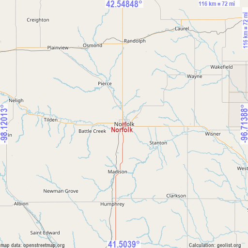
Norfolk GPS coordinates[2]
42° 1' 42.024" North, 97° 25' 1.2" West
| Map corner | latitude | longitude |
|---|---|---|
| Upper-left | 42.54848°, | -98.12013° |
| Center: | 42.02834°, | -97.417° |
| Lower-right: | 41.5039°, | -96.71388° |
| Map W x H: | 116.1×116.1 km | = 72.1×72.1mi |
| max Lat: | 71.29058° ⇑24.1% North |
| Norfolk: | 42.02834° |
| min Lat: | ⇓75.9% South 19.06759° |
| min Long | Norfolk | max Long |
| -171.73463° | -97.417° | -66.98998° |
| W 23.1%⇐ | ⇒76.9% E |
Elevation
Elevation of Norfolk is 463 m = 1519 ft, and this is 168.2 m = 552 ft above average elevation for this country.
| Max E: |
3189 m = 10463 ft | 13.2% |
| Norfolk | 463 m 1519 ft | |
| Avg. | 294.8 m = 967 ft | |
Min E: |
-60 m = -197 ft | 86.8% |
See also: United States elevation on elevation.city.
Geographical zone
Norfolk is located in North temperate zone (between Tropic of Cancer and the Arctic Circle). Distance of this Northern Tropic circle is 2067.2 km =1284.5 mi to South.| Distance of | km | miles | from Norfolk |
|---|---|---|---|
| North Pole | 5333.9 | 3314.3 | to North |
| Arctic Circle | 2728.1 | 1695.2 | to North |
| Tropic Cancer | 2067.2 | 1284.5 | to South |
| Equator | 4673.1 | 2903.7 | to South |


Nearby cities:
15 places around Norfolk: (largest is in red/bold)
• Battle Creek
15.3 km =9.5 mi,  257°
257°
• Beemer
51.2 km =31.8 mi,  102°
102°
• Clarkson
41.5 km =25.8 mi,  143°
143°
• Howells
48.1 km =29.9 mi,  134°
134°
• Humphrey
37.8 km =23.5 mi,  188°
188°
• Madison
22.5 km =14 mi, 188°
• Newman Grove
42.9 km =26.7 mi,  223°
223°
• Osmond
39.7 km =24.7 mi,  338°
338°
• Pierce
21 km =13 mi,  334°
334°
• Plainview
47.2 km =29.3 mi,  319°
319°
• Randolph
39.3 km =24.4 mi,  7°
7°
• Stanton
18.2 km =11.3 mi,  118°
118°
• Tilden
34.5 km =21.4 mi,  273°
273°
• Wayne
39.9 km =24.8 mi,  55°
55°
• Wisner
41.8 km =26 mi, 96°
Sources, notices
• [Note1] Compared only with cities in United States existing in our database
• [Src1] Map data: © OpenStreetMap contributors (CC-BY-SA)
• [Src2] Other city data from geonames.org with taken over terms of usage.
• [Src3] Geographical zone / Annual Mean Temperature by Robert A. Rohde @ Wikipedia
