Battle Creek geodata
Battle Creek (Nebraska) is a populated place; located in United States in America/Chicago (GMT-5) time zone. With population of 1,193 people, there are 15161 cities with bigger population in this country. Compared to other cities in United States, 75.7% of cities are located further ↓South; 77.4% of cities are located further →East and 87.5% of cities have lower elevation than Battle Creek. Note1


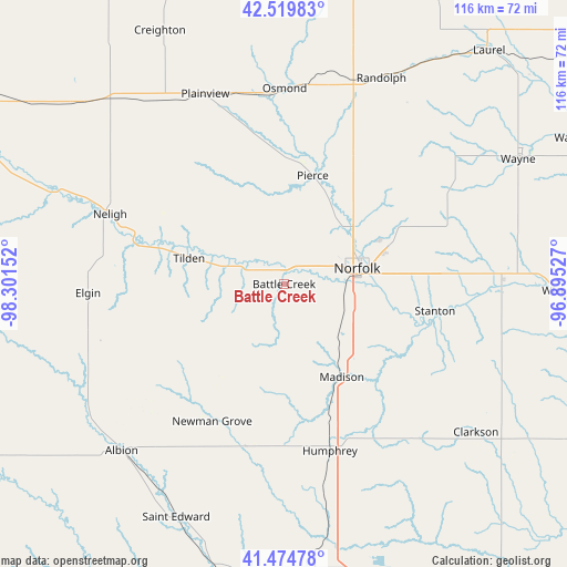
Battle Creek GPS coordinates[2]
41° 59' 58.02" North, 97° 35' 54.204" West
| Map corner | latitude | longitude |
|---|---|---|
| Upper-left | 42.51983°, | -98.30152° |
| Center: | 41.99945°, | -97.59839° |
| Lower-right: | 41.47478°, | -96.89527° |
| Map W x H: | 116.2×116.2 km | = 72.2×72.2mi |
| max Lat: | 71.29058° ⇑24.3% North |
| Battle Creek: | 41.99945° |
| min Lat: | ⇓75.7% South 19.06759° |
| min Long | Battle Creek | max Long |
| -171.73463° | -97.59839° | -66.98998° |
| W 22.6%⇐ | ⇒77.4% E |
Elevation
Elevation of Battle Creek is 486 m = 1594 ft, and this is 191.2 m = 627 ft above average elevation for this country.
| Max E: |
3189 m = 10463 ft | 12.5% |
| Battle Creek | 486 m 1594 ft | |
| Avg. | 294.8 m = 967 ft | |
Min E: |
-60 m = -197 ft | 87.5% |
See also: United States elevation on elevation.city.
Geographical zone
Battle Creek is located in North temperate zone (between Tropic of Cancer and the Arctic Circle). Distance of this Northern Tropic circle is 2064 km =1282.5 mi to South.| Distance of | km | miles | from Battle Creek |
|---|---|---|---|
| North Pole | 5337.2 | 3316.4 | to North |
| Arctic Circle | 2731.3 | 1697.2 | to North |
| Tropic Cancer | 2064 | 1282.5 | to South |
| Equator | 4669.9 | 2901.7 | to South |


Nearby cities:
15 places around Battle Creek: (largest is in red/bold)
• Albion
48 km =29.8 mi,  224°
224°
• Clarkson
49.7 km =30.9 mi,  127°
127°
• Elgin
40.1 km =24.9 mi,  267°
267°
• Humphrey
35.5 km =22.1 mi,  164°
164°
• Madison
22.4 km =13.9 mi,  148°
148°
• Neligh
38.4 km =23.9 mi,  291°
291°
• Newman Grove
31.4 km =19.5 mi,  207°
207°
• Norfolk
15.3 km =9.5 mi,  77°
77°
• Osmond
40.1 km =24.9 mi,  0°
0°
• Pierce
23 km =14.3 mi,  14°
14°
• Plainview
42.1 km =26.2 mi,  337°
337°
• Randolph
46.6 km =29 mi,  25°
25°
• Saint Edward
52.6 km =32.7 mi,  204°
204°
• Stanton
31.4 km =19.5 mi,  100°
100°
• Tilden
20.2 km =12.6 mi, 285°
Sources, notices
• [Note1] Compared only with cities in United States existing in our database
• [Src1] Map data: © OpenStreetMap contributors (CC-BY-SA)
• [Src2] Other city data from geonames.org with taken over terms of usage.
• [Src3] Geographical zone / Annual Mean Temperature by Robert A. Rohde @ Wikipedia
