Westmoreland geodata
Westmoreland (New Hampshire) is a populated place; located in United States in America/New_York (GMT-4) time zone. With population of 1,861 people, there are 12335 cities with bigger population in this country. Compared to other cities in United States, 83% of cities are located further ↓South; 95% of cities are located further ←West and 64.8% of cities have higher elevation than Westmoreland. Note1
Administrative division(s):
- Level 1: New Hampshire
- Level 2: Cheshire County
- Level 3: Town of Westmoreland


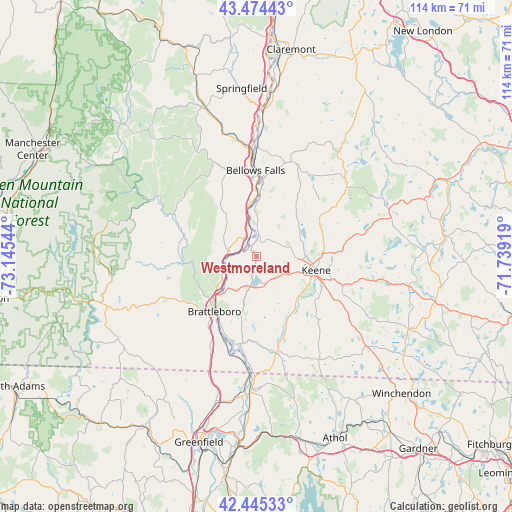
Westmoreland GPS coordinates[2]
42° 57' 43.308" North, 72° 26' 32.316" West
| Map corner | latitude | longitude |
|---|---|---|
| Upper-left | 43.47443°, | -73.14544° |
| Center: | 42.96203°, | -72.44231° |
| Lower-right: | 42.44533°, | -71.73919° |
| Map W x H: | 114.4×114.4 km | = 71.1×71.1mi |
| max Lat: | 71.29058° ⇑17% North |
| Westmoreland: | 42.96203° |
| min Lat: | ⇓83% South 19.06759° |
| min Long | Westmoreland | max Long |
| -171.73463° | -72.44231° | -66.98998° |
| W 95%⇐ | ⇒5% E |
Elevation
Elevation of Westmoreland is 129 m = 423 ft, and this is 165.8 m = 544 ft below average elevation for this country.
| Max E: |
3189 m = 10463 ft | 64.8% |
| Avg. | 294.8 m = 967 ft | |
| Westmoreland | 129 m = 423 ft | |
Min E: |
-60 m = -197 ft | 35.2% |
See also: United States elevation on elevation.city.
Geographical zone
Westmoreland is located in North temperate zone (between Tropic of Cancer and the Arctic Circle). Distance of this Northern Tropic circle is 2171 km =1349 mi to South.| Distance of | km | miles | from Westmoreland |
|---|---|---|---|
| North Pole | 5230.1 | 3249.8 | to North |
| Arctic Circle | 2624.2 | 1630.6 | to North |
| Tropic Cancer | 2171 | 1349 | to South |
| Equator | 4776.9 | 2968.2 | to South |


Nearby cities:
15 places around Westmoreland: (largest is in red/bold)
• Bellows Falls
19.1 km =11.9 mi,  359°
359°
• Brattleboro
15.5 km =9.6 mi,  217°
217°
• Chesterfield
8.6 km =5.3 mi,  195°
195°
• Gilsum
17.5 km =10.9 mi,  56°
56°
• Hinsdale
19.9 km =12.4 mi,  190°
190°
• Keene
13.7 km =8.5 mi,  103°
103°
• Newfane
17.6 km =10.9 mi,  278°
278°
• North Walpole
19.7 km =12.2 mi, 358°
• Putney
6.6 km =4.1 mi, 282°
• Sullivan
18.9 km =11.7 mi,  72°
72°
• Surry
11.6 km =7.2 mi, 57°
• Swanzey
16.6 km =10.3 mi,  128°
128°
• Walpole
13.1 km =8.1 mi,  5°
5°
• West Brattleboro
17.6 km =10.9 mi,  227°
227°
• West Swanzey
14.2 km =8.8 mi,  136°
136°
Sources, notices
• [Note1] Compared only with cities in United States existing in our database
• [Src1] Map data: © OpenStreetMap contributors (CC-BY-SA)
• [Src2] Other city data from geonames.org with taken over terms of usage.
• [Src3] Geographical zone / Annual Mean Temperature by Robert A. Rohde @ Wikipedia
