Sunnyside geodata
Sunnyside (New York) is a populated place; located in United States in America/New_York (GMT-4) time zone. With population of 49,833 people, there are 955 cities with bigger population in this country. Compared to other cities in United States, 62.2% of cities are located further ↓South; 91% of cities are located further ←West and 97.4% of cities have higher elevation than Sunnyside. Note1


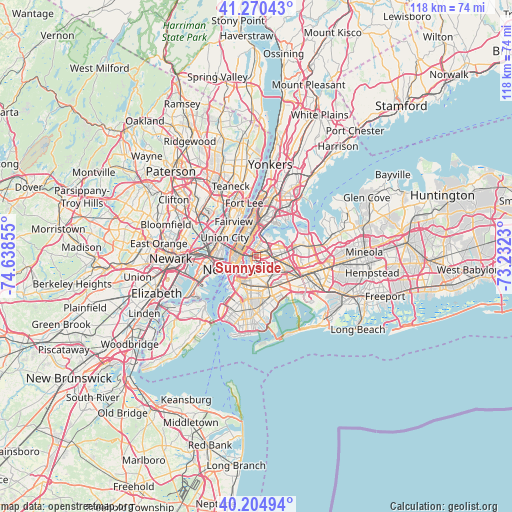
Sunnyside GPS coordinates[2]
40° 44' 23.352" North, 73° 56' 7.512" West
| Map corner | latitude | longitude |
|---|---|---|
| Upper-left | 41.27043°, | -74.63855° |
| Center: | 40.73982°, | -73.93542° |
| Lower-right: | 40.20494°, | -73.2323° |
| Map W x H: | 118.5×118.5 km | = 73.6×73.6mi |
| max Lat: | 71.29058° ⇑37.8% North |
| Sunnyside: | 40.73982° |
| min Lat: | ⇓62.2% South 19.06759° |
| min Long | Sunnyside | max Long |
| -171.73463° | -73.93542° | -66.98998° |
| W 91%⇐ | ⇒9% E |
Elevation
Elevation of Sunnyside is 6 m = 20 ft, and this is 288.8 m = 948 ft below average elevation for this country.
| Max E: |
3189 m = 10463 ft | 97.4% |
| Avg. | 294.8 m = 967 ft | |
| Sunnyside | 6 m = 20 ft | |
Min E: |
-60 m = -197 ft | 2.6% |
See also: Sunnyside elevation on elevation.city.
Geographical zone
Sunnyside is located in North temperate zone (between Tropic of Cancer and the Arctic Circle). Distance of this Northern Tropic circle is 1923.9 km =1195.5 mi to South.| Distance of | km | miles | from Sunnyside |
|---|---|---|---|
| North Pole | 5477.2 | 3403.4 | to North |
| Arctic Circle | 2871.3 | 1784.1 | to North |
| Tropic Cancer | 1923.9 | 1195.5 | to South |
| Equator | 4529.8 | 2814.7 | to South |


Nearby cities:
15 places around Sunnyside: (largest is in red/bold)
• Astoria
3.6 km =2.2 mi,  7°
7°
• Bushwick
5.3 km =3.3 mi,  164°
164°
• East Village
4.5 km =2.8 mi,  254°
254°
• Elmhurst
4.9 km =3 mi,  94°
94°
• Gramercy Park
4.3 km =2.7 mi,  266°
266°
• Greenpoint
2.2 km =1.4 mi,  216°
216°
• Hell's Kitchen
5.4 km =3.4 mi,  300°
300°
• Jackson Heights
4.6 km =2.9 mi,  67°
67°
• Long Island City
1.3 km =0.8 mi, 296°
• Maspeth
2.7 km =1.7 mi,  133°
133°
• Middle Village
5.3 km =3.3 mi,  119°
119°
• Ridgewood
5.1 km =3.2 mi,  150°
150°
• Steinway
4.7 km =2.9 mi,  34°
34°
• Williamsburg
3.2 km =2 mi,  208°
208°
• Woodside
2.6 km =1.6 mi,  76°
76°
Sources, notices
• [Note1] Compared only with cities in United States existing in our database
• [Src1] Map data: © OpenStreetMap contributors (CC-BY-SA)
• [Src2] Other city data from geonames.org with taken over terms of usage.
• [Src3] Geographical zone / Annual Mean Temperature by Robert A. Rohde @ Wikipedia
