Ashland geodata
Ashland (Ohio) is a seat of a second-order administrative division; located in United States in America/New_York (GMT-4) time zone. With population of 20,317 people, there are 2474 cities with bigger population in this country. Compared to other cities in United States, 64.2% of cities are located further ↓South; 64.6% of cities are located further ←West and 76.6% of cities have lower elevation than Ashland. Note1


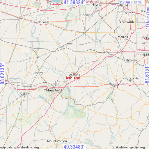
Ashland GPS coordinates[2]
40° 52' 7.212" North, 82° 19' 5.592" West
| Map corner | latitude | longitude |
|---|---|---|
| Upper-left | 41.39824°, | -83.02135° |
| Center: | 40.86867°, | -82.31822° |
| Lower-right: | 40.33483°, | -81.6151° |
| Map W x H: | 118.2×118.2 km | = 73.4×73.4mi |
| max Lat: | 71.29058° ⇑35.8% North |
| Ashland: | 40.86867° |
| min Lat: | ⇓64.2% South 19.06759° |
| min Long | Ashland | max Long |
| -171.73463° | -82.31822° | -66.98998° |
| W 64.6%⇐ | ⇒35.4% E |
Elevation
Elevation of Ashland is 325 m = 1066 ft, and this is 30.2 m = 99 ft above average elevation for this country.
| Max E: |
3189 m = 10463 ft | 23.4% |
| Ashland | 325 m 1066 ft | |
| Avg. | 294.8 m = 967 ft | |
Min E: |
-60 m = -197 ft | 76.6% |
See also: United States elevation on elevation.city.
Geographical zone
Ashland is located in North temperate zone (between Tropic of Cancer and the Arctic Circle). Distance of this Northern Tropic circle is 1938.3 km =1204.4 mi to South.| Distance of | km | miles | from Ashland |
|---|---|---|---|
| North Pole | 5462.9 | 3394.5 | to North |
| Arctic Circle | 2857 | 1775.3 | to North |
| Tropic Cancer | 1938.3 | 1204.4 | to South |
| Equator | 4544.2 | 2823.6 | to South |


Nearby cities:
15 places around Ashland: (largest is in red/bold)
• Greenwich
24.4 km =15.2 mi,  317°
317°
• Jeromesville
12.6 km =7.8 mi,  124°
124°
• Lexington
30.7 km =19.1 mi,  226°
226°
• Lincoln Heights
17.7 km =11 mi, 232°
• Lodi
31.6 km =19.6 mi,  54°
54°
• Loudonville
26.9 km =16.7 mi,  164°
164°
• Lucas
20 km =12.4 mi,  204°
204°
• Mansfield
20.6 km =12.8 mi, 233°
• New London
25 km =15.5 mi,  344°
344°
• Ontario
25.9 km =16.1 mi,  242°
242°
• Perrysville
23.5 km =14.6 mi,  178°
178°
• Shelby
28.9 km =18 mi,  272°
272°
• Shiloh
26.1 km =16.2 mi,  294°
294°
• Spencer
30.5 km =19 mi,  32°
32°
• West Salem
20.9 km =13 mi,  56°
56°
Sources, notices
• [Note1] Compared only with cities in United States existing in our database
• [Src1] Map data: © OpenStreetMap contributors (CC-BY-SA)
• [Src2] Other city data from geonames.org with taken over terms of usage.
• [Src3] Geographical zone / Annual Mean Temperature by Robert A. Rohde @ Wikipedia
