Jeromesville geodata
Jeromesville (Ohio) is a populated place; located in United States in America/New_York (GMT-4) time zone. With population of 562 people, there are 20130 cities with bigger population in this country. Compared to other cities in United States, 63.3% of cities are located further ↓South; 64.9% of cities are located further ←West and 74.2% of cities have lower elevation than Jeromesville. Note1


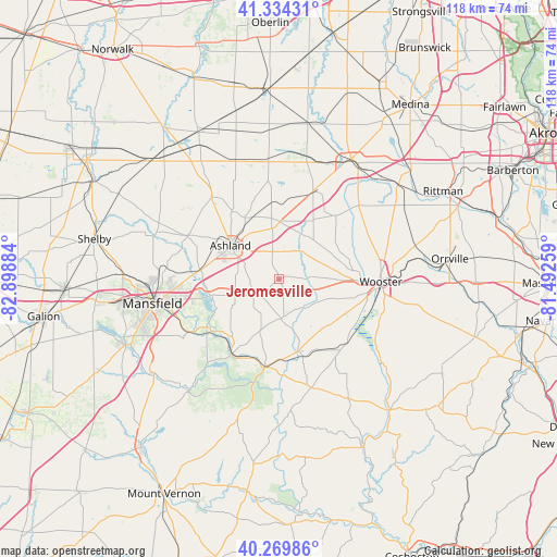
Jeromesville GPS coordinates[2]
40° 48' 15.192" North, 82° 11' 44.556" West
| Map corner | latitude | longitude |
|---|---|---|
| Upper-left | 41.33431°, | -82.89884° |
| Center: | 40.80422°, | -82.19571° |
| Lower-right: | 40.26986°, | -81.49259° |
| Map W x H: | 118.4×118.4 km | = 73.6×73.6mi |
| max Lat: | 71.29058° ⇑36.7% North |
| Jeromesville: | 40.80422° |
| min Lat: | ⇓63.3% South 19.06759° |
| min Long | Jeromesville | max Long |
| -171.73463° | -82.19571° | -66.98998° |
| W 64.9%⇐ | ⇒35.1% E |
Elevation
Elevation of Jeromesville is 308 m = 1010 ft, and this is 13.2 m = 43 ft above average elevation for this country.
| Max E: |
3189 m = 10463 ft | 25.8% |
| Jeromesville | 308 m 1010 ft | |
| Avg. | 294.8 m = 967 ft | |
Min E: |
-60 m = -197 ft | 74.2% |
See also: United States elevation on elevation.city.
Geographical zone
Jeromesville is located in North temperate zone (between Tropic of Cancer and the Arctic Circle). Distance of this Northern Tropic circle is 1931.1 km =1199.9 mi to South.| Distance of | km | miles | from Jeromesville |
|---|---|---|---|
| North Pole | 5470.1 | 3399 | to North |
| Arctic Circle | 2864.2 | 1779.7 | to North |
| Tropic Cancer | 1931.1 | 1199.9 | to South |
| Equator | 4537 | 2819.2 | to South |


Nearby cities:
15 places around Jeromesville: (largest is in red/bold)
• Apple Creek
30.6 km =19 mi,  101°
101°
• Ashland
12.6 km =7.8 mi,  304°
304°
• Butler
30.8 km =19.1 mi,  218°
218°
• Creston
32.5 km =20.2 mi,  51°
51°
• Lincoln Heights
24.6 km =15.3 mi,  261°
261°
• Lodi
29.8 km =18.5 mi,  31°
31°
• Loudonville
19 km =11.8 mi,  189°
189°
• Lucas
21.7 km =13.5 mi,  239°
239°
• Mansfield
27.4 km =17 mi, 259°
• Perrysville
19 km =11.8 mi,  210°
210°
• Shreve
20 km =12.4 mi,  132°
132°
• Smithville
28.8 km =17.9 mi,  77°
77°
• West Salem
19.9 km =12.4 mi,  21°
21°
• Westfield Center
33.1 km =20.6 mi,  41°
41°
• Wooster
21.8 km =13.5 mi,  89°
89°
Sources, notices
• [Note1] Compared only with cities in United States existing in our database
• [Src1] Map data: © OpenStreetMap contributors (CC-BY-SA)
• [Src2] Other city data from geonames.org with taken over terms of usage.
• [Src3] Geographical zone / Annual Mean Temperature by Robert A. Rohde @ Wikipedia
