Mansfield geodata
Mansfield (Ohio) is a seat of a second-order administrative division; located in United States in America/New_York (GMT-4) time zone. With population of 46,830 people, there are 1026 cities with bigger population in this country. Compared to other cities in United States, 62.5% of cities are located further ↓South; 63.7% of cities are located further ←West and 82.5% of cities have lower elevation than Mansfield. Note1


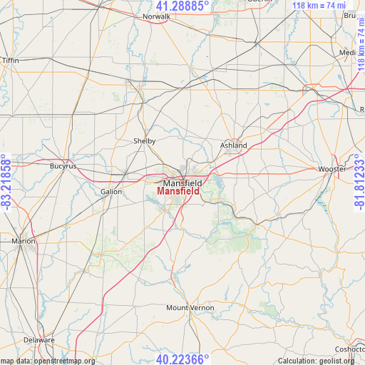
Mansfield GPS coordinates[2]
40° 45' 30.204" North, 82° 30' 55.62" West
| Map corner | latitude | longitude |
|---|---|---|
| Upper-left | 41.28885°, | -83.21858° |
| Center: | 40.75839°, | -82.51545° |
| Lower-right: | 40.22366°, | -81.81233° |
| Map W x H: | 118.4×118.4 km | = 73.6×73.6mi |
| max Lat: | 71.29058° ⇑37.5% North |
| Mansfield: | 40.75839° |
| min Lat: | ⇓62.5% South 19.06759° |
| min Long | Mansfield | max Long |
| -171.73463° | -82.51545° | -66.98998° |
| W 63.7%⇐ | ⇒36.3% E |
Elevation
Elevation of Mansfield is 382 m = 1253 ft, and this is 87.2 m = 286 ft above average elevation for this country.
| Max E: |
3189 m = 10463 ft | 17.5% |
| Mansfield | 382 m 1253 ft | |
| Avg. | 294.8 m = 967 ft | |
Min E: |
-60 m = -197 ft | 82.5% |
See also: Mansfield elevation on elevation.city.
Geographical zone
Mansfield is located in North temperate zone (between Tropic of Cancer and the Arctic Circle). Distance of this Northern Tropic circle is 1926 km =1196.8 mi to South.| Distance of | km | miles | from Mansfield |
|---|---|---|---|
| North Pole | 5475.2 | 3402.1 | to North |
| Arctic Circle | 2869.3 | 1782.9 | to North |
| Tropic Cancer | 1926 | 1196.8 | to South |
| Equator | 4531.9 | 2816 | to South |


Nearby cities:
15 places around Mansfield: (largest is in red/bold)
• Ashland
20.6 km =12.8 mi,  53°
53°
• Bellville
15.4 km =9.6 mi,  178°
178°
• Butler
20.4 km =12.7 mi,  158°
158°
• Crestline
18.9 km =11.7 mi,  279°
279°
• Galion
23.3 km =14.5 mi,  263°
263°
• Jeromesville
27.4 km =17 mi,  79°
79°
• Lexington
10.5 km =6.5 mi,  212°
212°
• Lincoln Heights
3 km =1.9 mi,  61°
61°
• Loudonville
27.4 km =17 mi,  119°
119°
• Lucas
10.1 km =6.3 mi,  125°
125°
• Ontario
6.3 km =3.9 mi,  271°
271°
• Perrysville
20.5 km =12.7 mi, 123°
• Plymouth
29.3 km =18.2 mi,  334°
334°
• Shelby
18.4 km =11.4 mi,  318°
318°
• Shiloh
24.2 km =15 mi,  342°
342°
Sources, notices
• [Note1] Compared only with cities in United States existing in our database
• [Src1] Map data: © OpenStreetMap contributors (CC-BY-SA)
• [Src2] Other city data from geonames.org with taken over terms of usage.
• [Src3] Geographical zone / Annual Mean Temperature by Robert A. Rohde @ Wikipedia
