Lexington geodata
Lexington (Ohio) is a populated place; located in United States in America/New_York (GMT-4) time zone. With population of 4,731 people, there are 7410 cities with bigger population in this country. Compared to other cities in United States, 61.2% of cities are located further ↓South; 63.4% of cities are located further ←West and 81.6% of cities have lower elevation than Lexington. Note1


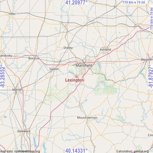
Lexington GPS coordinates[2]
40° 40' 43.212" North, 82° 34' 56.604" West
| Map corner | latitude | longitude |
|---|---|---|
| Upper-left | 41.20977°, | -83.28552° |
| Center: | 40.67867°, | -82.58239° |
| Lower-right: | 40.14331°, | -81.87927° |
| Map W x H: | 118.6×118.6 km | = 73.7×73.7mi |
| max Lat: | 71.29058° ⇑38.8% North |
| Lexington: | 40.67867° |
| min Lat: | ⇓61.2% South 19.06759° |
| min Long | Lexington | max Long |
| -171.73463° | -82.58239° | -66.98998° |
| W 63.4%⇐ | ⇒36.6% E |
Elevation
Elevation of Lexington is 371 m = 1217 ft, and this is 76.2 m = 250 ft above average elevation for this country.
| Max E: |
3189 m = 10463 ft | 18.4% |
| Lexington | 371 m 1217 ft | |
| Avg. | 294.8 m = 967 ft | |
Min E: |
-60 m = -197 ft | 81.6% |
See also: United States elevation on elevation.city.
Geographical zone
Lexington is located in North temperate zone (between Tropic of Cancer and the Arctic Circle). Distance of this Northern Tropic circle is 1917.1 km =1191.2 mi to South.| Distance of | km | miles | from Lexington |
|---|---|---|---|
| North Pole | 5484 | 3407.6 | to North |
| Arctic Circle | 2878.1 | 1788.4 | to North |
| Tropic Cancer | 1917.1 | 1191.2 | to South |
| Equator | 4523 | 2810.5 | to South |


Nearby cities:
15 places around Lexington: (largest is in red/bold)
• Ashland
30.7 km =19.1 mi,  46°
46°
• Bellville
8.9 km =5.5 mi,  137°
137°
• Butler
16.7 km =10.4 mi,  127°
127°
• Crestline
17.8 km =11.1 mi,  312°
312°
• Fredericktown
22.2 km =13.8 mi,  170°
170°
• Galion
18.5 km =11.5 mi,  289°
289°
• Lincoln Heights
13.2 km =8.2 mi,  38°
38°
• Loudonville
29.8 km =18.5 mi,  99°
99°
• Lucas
14.1 km =8.8 mi,  78°
78°
• Mansfield
10.5 km =6.5 mi,  32°
32°
• Mount Gilead
25.2 km =15.7 mi,  235°
235°
• Ontario
9 km =5.6 mi,  355°
355°
• Perrysville
23 km =14.3 mi, 95°
• Shelby
23.5 km =14.6 mi,  343°
343°
• Shiloh
32.1 km =19.9 mi, 357°
Sources, notices
• [Note1] Compared only with cities in United States existing in our database
• [Src1] Map data: © OpenStreetMap contributors (CC-BY-SA)
• [Src2] Other city data from geonames.org with taken over terms of usage.
• [Src3] Geographical zone / Annual Mean Temperature by Robert A. Rohde @ Wikipedia
