Nevada geodata
Nevada (Ohio) is a populated place; located in United States in America/New_York (GMT-4) time zone. With population of 740 people, there are 18306 cities with bigger population in this country. Compared to other cities in United States, 63.5% of cities are located further ↓South; 61.7% of cities are located further ←West and 69.3% of cities have lower elevation than Nevada. Note1


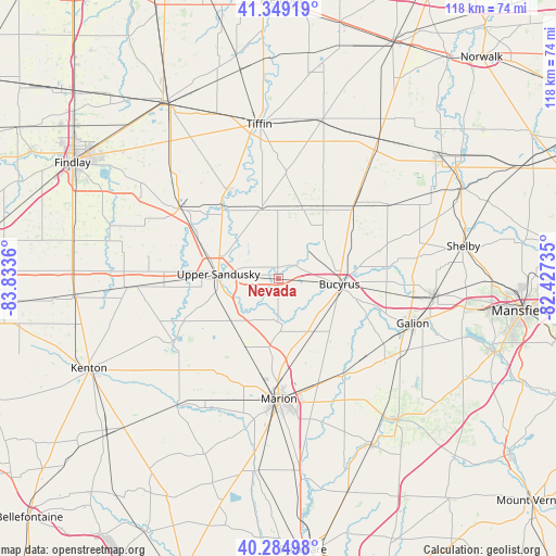
Nevada GPS coordinates[2]
40° 49' 9.192" North, 83° 7' 49.692" West
| Map corner | latitude | longitude |
|---|---|---|
| Upper-left | 41.34919°, | -83.8336° |
| Center: | 40.81922°, | -83.13047° |
| Lower-right: | 40.28498°, | -82.42735° |
| Map W x H: | 118.3×118.3 km | = 73.5×73.5mi |
| max Lat: | 71.29058° ⇑36.5% North |
| Nevada: | 40.81922° |
| min Lat: | ⇓63.5% South 19.06759° |
| min Long | Nevada | max Long |
| -171.73463° | -83.13047° | -66.98998° |
| W 61.7%⇐ | ⇒38.3% E |
Elevation
Elevation of Nevada is 282 m = 925 ft, and this is 12.8 m = 42 ft below average elevation for this country.
| Max E: |
3189 m = 10463 ft | 30.7% |
| Avg. | 294.8 m = 967 ft | |
| Nevada | 282 m = 925 ft | |
Min E: |
-60 m = -197 ft | 69.3% |
See also: United States elevation on elevation.city.
Geographical zone
Nevada is located in North temperate zone (between Tropic of Cancer and the Arctic Circle). Distance of this Northern Tropic circle is 1932.8 km =1201 mi to South.| Distance of | km | miles | from Nevada |
|---|---|---|---|
| North Pole | 5468.4 | 3397.9 | to North |
| Arctic Circle | 2862.5 | 1778.7 | to North |
| Tropic Cancer | 1932.8 | 1201 | to South |
| Equator | 4538.7 | 2820.2 | to South |


Nearby cities:
15 places around Nevada: (largest is in red/bold)
• Attica
34.1 km =21.2 mi,  36°
36°
• Bloomville
27.6 km =17.1 mi,  20°
20°
• Bucyrus
13.1 km =8.1 mi,  95°
95°
• Caledonia
24.5 km =15.2 mi,  146°
146°
• Carey
25.9 km =16.1 mi,  304°
304°
• Crestline
33.3 km =20.7 mi, 96°
• Forest
32 km =19.9 mi,  266°
266°
• Galion
30.2 km =18.8 mi,  108°
108°
• La Rue
34.5 km =21.4 mi,  218°
218°
• Marion
25.6 km =15.9 mi,  179°
179°
• New Washington
28.1 km =17.5 mi,  55°
55°
• Sycamore
14.9 km =9.3 mi,  346°
346°
• Tiffin
33.1 km =20.6 mi, 353°
• Upper Sandusky
12.7 km =7.9 mi, 274°
• Waynesburg
32.5 km =20.2 mi, 61°
Sources, notices
• [Note1] Compared only with cities in United States existing in our database
• [Src1] Map data: © OpenStreetMap contributors (CC-BY-SA)
• [Src2] Other city data from geonames.org with taken over terms of usage.
• [Src3] Geographical zone / Annual Mean Temperature by Robert A. Rohde @ Wikipedia
