Dunkirk geodata
Dunkirk (Ohio) is a populated place; located in United States in America/New_York (GMT-4) time zone. With population of 862 people, there are 17264 cities with bigger population in this country. Compared to other cities in United States, 63% of cities are located further ↓South; 60.3% of cities are located further ←West and 70.4% of cities have lower elevation than Dunkirk. Note1


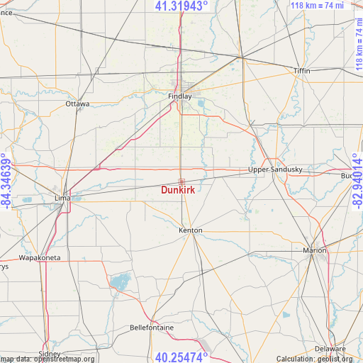
Dunkirk GPS coordinates[2]
40° 47' 21.192" North, 83° 38' 35.736" West
| Map corner | latitude | longitude |
|---|---|---|
| Upper-left | 41.31943°, | -84.34639° |
| Center: | 40.78922°, | -83.64326° |
| Lower-right: | 40.25474°, | -82.94014° |
| Map W x H: | 118.4×118.4 km | = 73.6×73.6mi |
| max Lat: | 71.29058° ⇑37% North |
| Dunkirk: | 40.78922° |
| min Lat: | ⇓63% South 19.06759° |
| min Long | Dunkirk | max Long |
| -171.73463° | -83.64326° | -66.98998° |
| W 60.3%⇐ | ⇒39.7% E |
Elevation
Elevation of Dunkirk is 288 m = 945 ft, and this is 6.8 m = 22 ft below average elevation for this country.
| Max E: |
3189 m = 10463 ft | 29.6% |
| Avg. | 294.8 m = 967 ft | |
| Dunkirk | 288 m = 945 ft | |
Min E: |
-60 m = -197 ft | 70.4% |
See also: United States elevation on elevation.city.
Geographical zone
Dunkirk is located in North temperate zone (between Tropic of Cancer and the Arctic Circle). Distance of this Northern Tropic circle is 1929.4 km =1198.9 mi to South.| Distance of | km | miles | from Dunkirk |
|---|---|---|---|
| North Pole | 5471.7 | 3400 | to North |
| Arctic Circle | 2865.8 | 1780.7 | to North |
| Tropic Cancer | 1929.4 | 1198.9 | to South |
| Equator | 4535.3 | 2818.1 | to South |


Nearby cities:
15 places around Dunkirk: (largest is in red/bold)
• Ada
15.3 km =9.5 mi,  261°
261°
• Alger
19.3 km =12 mi,  241°
241°
• Arlington
11.6 km =7.2 mi,  357°
357°
• Belle Center
32.6 km =20.3 mi,  195°
195°
• Bluffton
23.8 km =14.8 mi,  299°
299°
• Carey
28.5 km =17.7 mi,  50°
50°
• Findlay
28.4 km =17.6 mi, 358°
• Forest
11.3 km =7 mi,  82°
82°
• Kenton
16.1 km =10 mi,  169°
169°
• La Rue
32.2 km =20 mi,  137°
137°
• Mount Victory
30.2 km =18.8 mi,  159°
159°
• Pandora
32 km =19.9 mi, 303°
• Rawson
22.3 km =13.9 mi,  327°
327°
• Upper Sandusky
30.8 km =19.1 mi, 82°
• Waynesfield
35 km =21.7 mi,  233°
233°
Sources, notices
• [Note1] Compared only with cities in United States existing in our database
• [Src1] Map data: © OpenStreetMap contributors (CC-BY-SA)
• [Src2] Other city data from geonames.org with taken over terms of usage.
• [Src3] Geographical zone / Annual Mean Temperature by Robert A. Rohde @ Wikipedia
