Crestline geodata
Crestline (Ohio) is a populated place; located in United States in America/New_York (GMT-4) time zone. With population of 4,438 people, there are 7706 cities with bigger population in this country. Compared to other cities in United States, 62.9% of cities are located further ↓South; 62.8% of cities are located further ←West and 79.7% of cities have lower elevation than Crestline. Note1


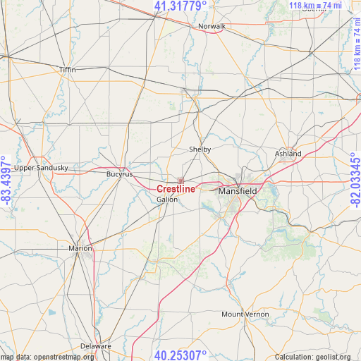
Crestline GPS coordinates[2]
40° 47' 15.216" North, 82° 44' 11.652" West
| Map corner | latitude | longitude |
|---|---|---|
| Upper-left | 41.31779°, | -83.4397° |
| Center: | 40.78756°, | -82.73657° |
| Lower-right: | 40.25307°, | -82.03345° |
| Map W x H: | 118.4×118.4 km | = 73.6×73.6mi |
| max Lat: | 71.29058° ⇑37.1% North |
| Crestline: | 40.78756° |
| min Lat: | ⇓62.9% South 19.06759° |
| min Long | Crestline | max Long |
| -171.73463° | -82.73657° | -66.98998° |
| W 62.8%⇐ | ⇒37.2% E |
Elevation
Elevation of Crestline is 350 m = 1148 ft, and this is 55.2 m = 181 ft above average elevation for this country.
| Max E: |
3189 m = 10463 ft | 20.3% |
| Crestline | 350 m 1148 ft | |
| Avg. | 294.8 m = 967 ft | |
Min E: |
-60 m = -197 ft | 79.7% |
See also: United States elevation on elevation.city.
Geographical zone
Crestline is located in North temperate zone (between Tropic of Cancer and the Arctic Circle). Distance of this Northern Tropic circle is 1929.2 km =1198.7 mi to South.| Distance of | km | miles | from Crestline |
|---|---|---|---|
| North Pole | 5471.9 | 3400.1 | to North |
| Arctic Circle | 2866 | 1780.8 | to North |
| Tropic Cancer | 1929.2 | 1198.7 | to South |
| Equator | 4535.2 | 2818 | to South |


Nearby cities:
15 places around Crestline: (largest is in red/bold)
• Bellville
26.6 km =16.5 mi,  134°
134°
• Bucyrus
20.2 km =12.6 mi,  276°
276°
• Caledonia
25.8 km =16 mi,  229°
229°
• Galion
7.5 km =4.7 mi,  216°
216°
• Lexington
17.8 km =11.1 mi, 132°
• Lincoln Heights
21.3 km =13.2 mi,  94°
94°
• Lucas
28.3 km =17.6 mi,  108°
108°
• Mansfield
18.9 km =11.7 mi,  99°
99°
• Mount Gilead
27.6 km =17.1 mi,  196°
196°
• New Washington
21.8 km =13.5 mi,  332°
332°
• Ontario
12.7 km =7.9 mi, 104°
• Plymouth
23.9 km =14.9 mi,  14°
14°
• Shelby
12.2 km =7.6 mi,  31°
31°
• Shiloh
23 km =14.3 mi, 29°
• Waynesburg
19.8 km =12.3 mi,  346°
346°
Sources, notices
• [Note1] Compared only with cities in United States existing in our database
• [Src1] Map data: © OpenStreetMap contributors (CC-BY-SA)
• [Src2] Other city data from geonames.org with taken over terms of usage.
• [Src3] Geographical zone / Annual Mean Temperature by Robert A. Rohde @ Wikipedia
