Garrettsville geodata
Garrettsville (Ohio) is a populated place; located in United States in America/New_York (GMT-4) time zone. With population of 2,328 people, there are 11024 cities with bigger population in this country. Compared to other cities in United States, 68.6% of cities are located further ↓South; 69.2% of cities are located further ←West and 73.5% of cities have lower elevation than Garrettsville. Note1


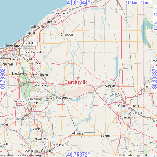
Garrettsville GPS coordinates[2]
41° 17' 3.192" North, 81° 5' 47.364" West
| Map corner | latitude | longitude |
|---|---|---|
| Upper-left | 41.81044°, | -81.79962° |
| Center: | 41.28422°, | -81.09649° |
| Lower-right: | 40.75372°, | -80.39337° |
| Map W x H: | 117.5×117.5 km | = 73×73mi |
| max Lat: | 71.29058° ⇑31.4% North |
| Garrettsville: | 41.28422° |
| min Lat: | ⇓68.6% South 19.06759° |
| min Long | Garrettsville | max Long |
| -171.73463° | -81.09649° | -66.98998° |
| W 69.2%⇐ | ⇒30.8% E |
Elevation
Elevation of Garrettsville is 304 m = 997 ft, and this is 9.2 m = 30 ft above average elevation for this country.
| Max E: |
3189 m = 10463 ft | 26.5% |
| Garrettsville | 304 m 997 ft | |
| Avg. | 294.8 m = 967 ft | |
Min E: |
-60 m = -197 ft | 73.5% |
See also: United States elevation on elevation.city.
Geographical zone
Garrettsville is located in North temperate zone (between Tropic of Cancer and the Arctic Circle). Distance of this Northern Tropic circle is 1984.5 km =1233.1 mi to South.| Distance of | km | miles | from Garrettsville |
|---|---|---|---|
| North Pole | 5416.7 | 3365.8 | to North |
| Arctic Circle | 2810.8 | 1746.5 | to North |
| Tropic Cancer | 1984.5 | 1233.1 | to South |
| Equator | 4590.4 | 2852.3 | to South |


Nearby cities:
15 places around Garrettsville: (largest is in red/bold)
• Aurora
21.1 km =13.1 mi,  280°
280°
• Bainbridge
23.3 km =14.5 mi,  299°
299°
• Burton
21.1 km =13.1 mi,  348°
348°
• Champion Heights
20.9 km =13 mi,  88°
88°
• Craig Beach
20.9 km =13 mi,  153°
153°
• Hiram
5 km =3.1 mi,  308°
308°
• Leavittsburg
18.8 km =11.7 mi,  102°
102°
• Mantua
10.7 km =6.6 mi,  269°
269°
• Middlefield
19.9 km =12.4 mi,  5°
5°
• Newton Falls
14.5 km =9 mi,  137°
137°
• Ravenna
18.6 km =11.6 mi,  220°
220°
• South Canal
15 km =9.3 mi, 142°
• Streetsboro
21.4 km =13.3 mi,  256°
256°
• Warren
23.8 km =14.8 mi, 102°
• Windham
6.7 km =4.2 mi, 144°
Sources, notices
• [Note1] Compared only with cities in United States existing in our database
• [Src1] Map data: © OpenStreetMap contributors (CC-BY-SA)
• [Src2] Other city data from geonames.org with taken over terms of usage.
• [Src3] Geographical zone / Annual Mean Temperature by Robert A. Rohde @ Wikipedia
