Harleysville geodata
Harleysville (Pennsylvania) is a populated place; located in United States in America/New_York (GMT-4) time zone. With population of 9,286 people, there are 4694 cities with bigger population in this country. Compared to other cities in United States, 56.4% of cities are located further ↓South; 86% of cities are located further ←West and 72.5% of cities have higher elevation than Harleysville. Note1
Administrative division(s):
- Level 1: Pennsylvania
- Level 2: Montgomery County
- Level 3: Township of Lower Salford


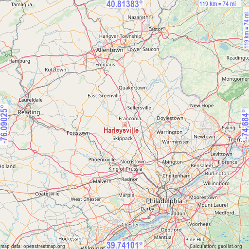
Harleysville GPS coordinates[2]
40° 16' 46.38" North, 75° 23' 13.632" West
| Map corner | latitude | longitude |
|---|---|---|
| Upper-left | 40.81383°, | -76.09025° |
| Center: | 40.27955°, | -75.38712° |
| Lower-right: | 39.74101°, | -74.684° |
| Map W x H: | 119.3×119.3 km | = 74.1×74.1mi |
| max Lat: | 71.29058° ⇑43.6% North |
| Harleysville: | 40.27955° |
| min Lat: | ⇓56.4% South 19.06759° |
| min Long | Harleysville | max Long |
| -171.73463° | -75.38712° | -66.98998° |
| W 86%⇐ | ⇒14% E |
Elevation
Elevation of Harleysville is 86 m = 282 ft, and this is 208.8 m = 685 ft below average elevation for this country.
| Max E: |
3189 m = 10463 ft | 72.5% |
| Avg. | 294.8 m = 967 ft | |
| Harleysville | 86 m = 282 ft | |
Min E: |
-60 m = -197 ft | 27.5% |
See also: United States elevation on elevation.city.
Geographical zone
Harleysville is located in North temperate zone (between Tropic of Cancer and the Arctic Circle). Distance of this Northern Tropic circle is 1872.7 km =1163.6 mi to South.| Distance of | km | miles | from Harleysville |
|---|---|---|---|
| North Pole | 5528.4 | 3435.2 | to North |
| Arctic Circle | 2922.5 | 1816 | to North |
| Tropic Cancer | 1872.7 | 1163.6 | to South |
| Equator | 4478.7 | 2782.9 | to South |


Nearby cities:
15 places around Harleysville: (largest is in red/bold)
• Collegeville
11.8 km =7.3 mi,  207°
207°
• Evansburg
11.5 km =7.1 mi,  197°
197°
• Hatfield
7.4 km =4.6 mi,  89°
89°
• Kulpsville
5.9 km =3.7 mi,  133°
133°
• Lansdale
9.7 km =6 mi,  115°
115°
• North Wales
12 km =7.5 mi, 129°
• Schwenksville
7 km =4.3 mi,  248°
248°
• Sellersville
10.8 km =6.7 mi,  40°
40°
• Silverdale
12.4 km =7.7 mi,  52°
52°
• Skippack
6.4 km =4 mi,  188°
188°
• Souderton
6.4 km =4 mi,  55°
55°
• Spring Mount
5.9 km =3.7 mi,  265°
265°
• Telford
6.9 km =4.3 mi, 46°
• Trappe
11.7 km =7.3 mi,  220°
220°
• Woxall
6.3 km =3.9 mi,  303°
303°
Sources, notices
• [Note1] Compared only with cities in United States existing in our database
• [Src1] Map data: © OpenStreetMap contributors (CC-BY-SA)
• [Src2] Other city data from geonames.org with taken over terms of usage.
• [Src3] Geographical zone / Annual Mean Temperature by Robert A. Rohde @ Wikipedia
