Baldwin geodata
Baldwin (Wisconsin) is a populated place; located in United States in America/Chicago (GMT-5) time zone. With population of 3,972 people, there are 8252 cities with bigger population in this country. Compared to other cities in United States, 92.4% of cities are located further ↓South; 64.9% of cities are located further →East and 78.6% of cities have lower elevation than Baldwin. Note1
Administrative division(s):
- Level 1: Wisconsin
- Level 2: Saint Croix County
- Level 3: Village of Baldwin


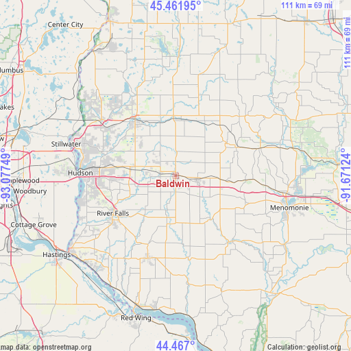
Baldwin GPS coordinates[2]
44° 57' 59.868" North, 92° 22' 27.696" West
| Map corner | latitude | longitude |
|---|---|---|
| Upper-left | 45.46195°, | -93.07749° |
| Center: | 44.96663°, | -92.37436° |
| Lower-right: | 44.467°, | -91.67124° |
| Map W x H: | 110.6×110.6 km | = 68.7×68.7mi |
| max Lat: | 71.29058° ⇑7.6% North |
| Baldwin: | 44.96663° |
| min Lat: | ⇓92.4% South 19.06759° |
| min Long | Baldwin | max Long |
| -171.73463° | -92.37436° | -66.98998° |
| W 35.1%⇐ | ⇒64.9% E |
Elevation
Elevation of Baldwin is 341 m = 1119 ft, and this is 46.2 m = 152 ft above average elevation for this country.
| Max E: |
3189 m = 10463 ft | 21.4% |
| Baldwin | 341 m 1119 ft | |
| Avg. | 294.8 m = 967 ft | |
Min E: |
-60 m = -197 ft | 78.6% |
See also: United States elevation on elevation.city.
Geographical zone
Baldwin is located in North temperate zone (between Tropic of Cancer and the Arctic Circle). Distance of this Northern Tropic circle is 2393.9 km =1487.5 mi to South.| Distance of | km | miles | from Baldwin |
|---|---|---|---|
| North Pole | 5007.2 | 3111.3 | to North |
| Arctic Circle | 2401.4 | 1492.2 | to North |
| Tropic Cancer | 2393.9 | 1487.5 | to South |
| Equator | 4999.8 | 3106.7 | to South |


Nearby cities:
15 places around Baldwin: (largest is in red/bold)
• Boyceville
27.6 km =17.1 mi,  71°
71°
• El Paso
22 km =13.7 mi,  173°
173°
• Ellsworth
27.5 km =17.1 mi,  198°
198°
• Elmwood
27.4 km =17 mi,  138°
138°
• Glenwood City
18.9 km =11.7 mi,  57°
57°
• Hammond
5 km =3.1 mi,  285°
285°
• Hudson
30.1 km =18.7 mi,  271°
271°
• New Richmond
21.6 km =13.4 mi,  323°
323°
• North Hudson
30.2 km =18.8 mi,  275°
275°
• River Falls
22.9 km =14.2 mi,  239°
239°
• Roberts
14.4 km =8.9 mi, 277°
• Somerset
29.3 km =18.2 mi,  306°
306°
• Spring Valley
17.2 km =10.7 mi, 141°
• Star Prairie
28.4 km =17.6 mi,  334°
334°
• Woodville
6.7 km =4.2 mi,  103°
103°
Sources, notices
• [Note1] Compared only with cities in United States existing in our database
• [Src1] Map data: © OpenStreetMap contributors (CC-BY-SA)
• [Src2] Other city data from geonames.org with taken over terms of usage.
• [Src3] Geographical zone / Annual Mean Temperature by Robert A. Rohde @ Wikipedia
