Ellsworth geodata
Ellsworth (Wisconsin) is a seat of a second-order administrative division; located in United States in America/Chicago (GMT-5) time zone. With population of 3,197 people, there are 9301 cities with bigger population in this country. Compared to other cities in United States, 91.3% of cities are located further ↓South; 65.2% of cities are located further →East and 81.5% of cities have lower elevation than Ellsworth. Note1


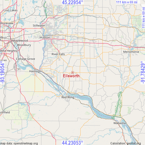
Ellsworth GPS coordinates[2]
44° 43' 55.884" North, 92° 29' 14.676" West
| Map corner | latitude | longitude |
|---|---|---|
| Upper-left | 45.22954°, | -93.19054° |
| Center: | 44.73219°, | -92.48741° |
| Lower-right: | 44.23053°, | -91.78429° |
| Map W x H: | 111.1×111.1 km | = 69×69mi |
| max Lat: | 71.29058° ⇑8.7% North |
| Ellsworth: | 44.73219° |
| min Lat: | ⇓91.3% South 19.06759° |
| min Long | Ellsworth | max Long |
| -171.73463° | -92.48741° | -66.98998° |
| W 34.8%⇐ | ⇒65.2% E |
Elevation
Elevation of Ellsworth is 370 m = 1214 ft, and this is 75.2 m = 247 ft above average elevation for this country.
| Max E: |
3189 m = 10463 ft | 18.5% |
| Ellsworth | 370 m 1214 ft | |
| Avg. | 294.8 m = 967 ft | |
Min E: |
-60 m = -197 ft | 81.5% |
See also: United States elevation on elevation.city.
Geographical zone
Ellsworth is located in North temperate zone (between Tropic of Cancer and the Arctic Circle). Distance of this Northern Tropic circle is 2367.8 km =1471.3 mi to South.| Distance of | km | miles | from Ellsworth |
|---|---|---|---|
| North Pole | 5033.3 | 3127.5 | to North |
| Arctic Circle | 2427.4 | 1508.3 | to North |
| Tropic Cancer | 2367.8 | 1471.3 | to South |
| Equator | 4973.8 | 3090.6 | to South |


Nearby cities:
15 places around Ellsworth: (largest is in red/bold)
• Afton
30.1 km =18.7 mi,  309°
309°
• Baldwin
27.5 km =17.1 mi,  18°
18°
• El Paso
12.1 km =7.5 mi,  69°
69°
• Elmwood
27.5 km =17.1 mi,  78°
78°
• Hammond
27.7 km =17.2 mi,  8°
8°
• Hastings
28.9 km =18 mi,  272°
272°
• Lake Saint Croix Beach
30.4 km =18.9 mi, 313°
• Lakeland
33.2 km =20.6 mi,  318°
318°
• Plum City
26 km =16.2 mi,  116°
116°
• Prescott
24.9 km =15.5 mi, 274°
• Red Wing
19.2 km =11.9 mi,  191°
191°
• River Falls
17.9 km =11.1 mi, 323°
• Roberts
28.5 km =17.7 mi,  349°
349°
• Spring Valley
23.3 km =14.5 mi,  57°
57°
• Woodville
29 km =18 mi,  32°
32°
Sources, notices
• [Note1] Compared only with cities in United States existing in our database
• [Src1] Map data: © OpenStreetMap contributors (CC-BY-SA)
• [Src2] Other city data from geonames.org with taken over terms of usage.
• [Src3] Geographical zone / Annual Mean Temperature by Robert A. Rohde @ Wikipedia
