El Paso geodata
El Paso (Wisconsin) is a populated place; located in United States in America/Chicago (GMT-5) time zone. With population of 680 people, there are 18874 cities with bigger population in this country. Compared to other cities in United States, 91.5% of cities are located further ↓South; 64.9% of cities are located further →East and 67.6% of cities have lower elevation than El Paso. Note1


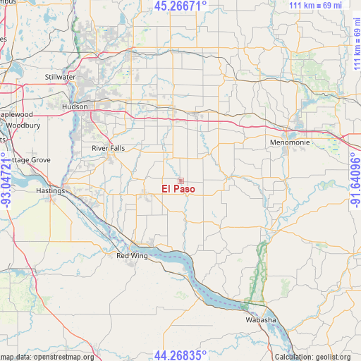
El Paso GPS coordinates[2]
44° 46' 10.884" North, 92° 20' 38.688" West
| Map corner | latitude | longitude |
|---|---|---|
| Upper-left | 45.26671°, | -93.04721° |
| Center: | 44.76969°, | -92.34408° |
| Lower-right: | 44.26835°, | -91.64096° |
| Map W x H: | 111×111 km | = 69×69mi |
| max Lat: | 71.29058° ⇑8.5% North |
| El Paso: | 44.76969° |
| min Lat: | ⇓91.5% South 19.06759° |
| min Long | El Paso | max Long |
| -171.73463° | -92.34408° | -66.98998° |
| W 35.1%⇐ | ⇒64.9% E |
Elevation
Elevation of El Paso is 274 m = 899 ft, and this is 20.8 m = 68 ft below average elevation for this country.
| Max E: |
3189 m = 10463 ft | 32.4% |
| Avg. | 294.8 m = 967 ft | |
| El Paso | 274 m = 899 ft | |
Min E: |
-60 m = -197 ft | 67.6% |
See also: United States elevation on elevation.city.
Geographical zone
El Paso is located in North temperate zone (between Tropic of Cancer and the Arctic Circle). Distance of this Northern Tropic circle is 2372 km =1473.9 mi to South.| Distance of | km | miles | from El Paso |
|---|---|---|---|
| North Pole | 5029.1 | 3124.9 | to North |
| Arctic Circle | 2423.3 | 1505.8 | to North |
| Tropic Cancer | 2372 | 1473.9 | to South |
| Equator | 4977.9 | 3093.1 | to South |


Nearby cities:
15 places around El Paso: (largest is in red/bold)
• Baldwin
22 km =13.7 mi,  353°
353°
• Durand
33.9 km =21.1 mi,  118°
118°
• Ellsworth
12.1 km =7.5 mi,  249°
249°
• Elmwood
15.7 km =9.8 mi,  85°
85°
• Glenwood City
34.8 km =21.6 mi,  22°
22°
• Hammond
24.4 km =15.2 mi,  342°
342°
• Lake City
36.1 km =22.4 mi,  170°
170°
• Menomonie
35.5 km =22.1 mi,  70°
70°
• Plum City
19.7 km =12.2 mi,  142°
142°
• Prescott
36.2 km =22.5 mi,  266°
266°
• Red Wing
27.5 km =17.1 mi,  213°
213°
• River Falls
24.3 km =15.1 mi,  294°
294°
• Roberts
29.1 km =18.1 mi,  324°
324°
• Spring Valley
11.8 km =7.3 mi,  44°
44°
• Woodville
20.8 km =12.9 mi,  11°
11°
Sources, notices
• [Note1] Compared only with cities in United States existing in our database
• [Src1] Map data: © OpenStreetMap contributors (CC-BY-SA)
• [Src2] Other city data from geonames.org with taken over terms of usage.
• [Src3] Geographical zone / Annual Mean Temperature by Robert A. Rohde @ Wikipedia
