Portland geodata
Portland (Wisconsin) is a populated place; located in United States in America/Chicago (GMT-5) time zone. With population of 1,065 people, there are 15868 cities with bigger population in this country. Compared to other cities in United States, 87.5% of cities are located further ↓South; 61.8% of cities are located further →East and 83.4% of cities have lower elevation than Portland. Note1


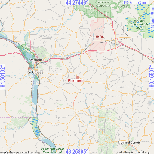
Portland GPS coordinates[2]
43° 46' 7.896" North, 90° 51' 29.484" West
| Map corner | latitude | longitude |
|---|---|---|
| Upper-left | 44.27446°, | -91.56132° |
| Center: | 43.76886°, | -90.85819° |
| Lower-right: | 43.25895°, | -90.15507° |
| Map W x H: | 112.9×112.9 km | = 70.2×70.2mi |
| max Lat: | 71.29058° ⇑12.5% North |
| Portland: | 43.76886° |
| min Lat: | ⇓87.5% South 19.06759° |
| min Long | Portland | max Long |
| -171.73463° | -90.85819° | -66.98998° |
| W 38.2%⇐ | ⇒61.8% E |
Elevation
Elevation of Portland is 396 m = 1299 ft, and this is 101.2 m = 332 ft above average elevation for this country.
| Max E: |
3189 m = 10463 ft | 16.6% |
| Portland | 396 m 1299 ft | |
| Avg. | 294.8 m = 967 ft | |
Min E: |
-60 m = -197 ft | 83.4% |
See also: United States elevation on elevation.city.
Geographical zone
Portland is located in North temperate zone (between Tropic of Cancer and the Arctic Circle). Distance of this Northern Tropic circle is 2260.7 km =1404.7 mi to South.| Distance of | km | miles | from Portland |
|---|---|---|---|
| North Pole | 5140.4 | 3194.1 | to North |
| Arctic Circle | 2534.5 | 1574.9 | to North |
| Tropic Cancer | 2260.7 | 1404.7 | to South |
| Equator | 4866.6 | 3024 | to South |


Nearby cities:
15 places around Portland: (largest is in red/bold)
• Bangor
17.4 km =10.8 mi,  322°
322°
• Cashton
7 km =4.3 mi,  115°
115°
• Coon Valley
14.5 km =9 mi,  239°
239°
• La Crosse
30.8 km =19.1 mi,  276°
276°
• La Farge
27.8 km =17.3 mi,  140°
140°
• Liberty
29.8 km =18.5 mi,  160°
160°
• Norwalk
20.2 km =12.6 mi,  70°
70°
• Ontario
21.9 km =13.6 mi,  102°
102°
• Rockland
16.1 km =10 mi,  342°
342°
• Saint Joseph
14.9 km =9.3 mi, 277°
• Sparta
19.8 km =12.3 mi,  10°
10°
• Viroqua
23.7 km =14.7 mi,  185°
185°
• West Salem
23 km =14.3 mi,  308°
308°
• Westby
12.5 km =7.8 mi,  178°
178°
• Wilton
27 km =16.8 mi,  79°
79°
Sources, notices
• [Note1] Compared only with cities in United States existing in our database
• [Src1] Map data: © OpenStreetMap contributors (CC-BY-SA)
• [Src2] Other city data from geonames.org with taken over terms of usage.
• [Src3] Geographical zone / Annual Mean Temperature by Robert A. Rohde @ Wikipedia
