Sparta geodata
Sparta (Wisconsin) is a seat of a second-order administrative division; located in United States in America/Chicago (GMT-5) time zone. With population of 9,679 people, there are 4561 cities with bigger population in this country. Compared to other cities in United States, 88.1% of cities are located further ↓South; 61.7% of cities are located further →East and 60.7% of cities have lower elevation than Sparta. Note1


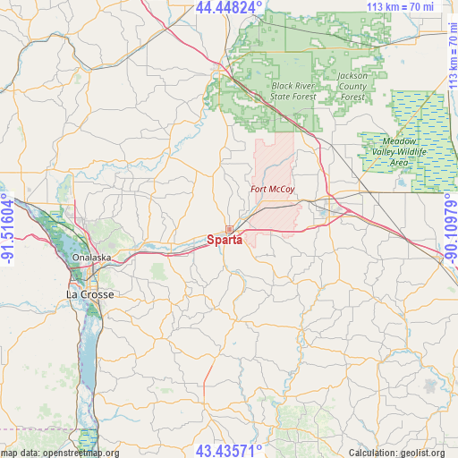
Sparta GPS coordinates[2]
43° 56' 38.868" North, 90° 48' 46.476" West
| Map corner | latitude | longitude |
|---|---|---|
| Upper-left | 44.44824°, | -91.51604° |
| Center: | 43.94413°, | -90.81291° |
| Lower-right: | 43.43571°, | -90.10979° |
| Map W x H: | 112.6×112.6 km | = 70×70mi |
| max Lat: | 71.29058° ⇑11.9% North |
| Sparta: | 43.94413° |
| min Lat: | ⇓88.1% South 19.06759° |
| min Long | Sparta | max Long |
| -171.73463° | -90.81291° | -66.98998° |
| W 38.3%⇐ | ⇒61.7% E |
Elevation
Elevation of Sparta is 243 m = 797 ft, and this is 51.8 m = 170 ft below average elevation for this country.
| Max E: |
3189 m = 10463 ft | 39.3% |
| Avg. | 294.8 m = 967 ft | |
| Sparta | 243 m = 797 ft | |
Min E: |
-60 m = -197 ft | 60.7% |
See also: United States elevation on elevation.city.
Geographical zone
Sparta is located in North temperate zone (between Tropic of Cancer and the Arctic Circle). Distance of this Northern Tropic circle is 2280.2 km =1416.9 mi to South.| Distance of | km | miles | from Sparta |
|---|---|---|---|
| North Pole | 5120.9 | 3182 | to North |
| Arctic Circle | 2515 | 1562.7 | to North |
| Tropic Cancer | 2280.2 | 1416.9 | to South |
| Equator | 4886.1 | 3036.1 | to South |


Nearby cities:
15 places around Sparta: (largest is in red/bold)
• Bangor
15.3 km =9.5 mi,  248°
248°
• Cashton
22.6 km =14 mi,  173°
173°
• Coon Valley
31.3 km =19.4 mi,  210°
210°
• Holmen
35.6 km =22.1 mi,  273°
273°
• North La Crosse
36.5 km =22.7 mi, 252°
• Norwalk
19.9 km =12.4 mi,  129°
129°
• Onalaska
34.5 km =21.4 mi,  258°
258°
• Ontario
30.1 km =18.7 mi,  143°
143°
• Portland
19.8 km =12.3 mi,  190°
190°
• Rockland
9.5 km =5.9 mi,  243°
243°
• Saint Joseph
25.5 km =15.8 mi,  226°
226°
• Tomah
25 km =15.5 mi,  81°
81°
• West Salem
22.1 km =13.7 mi, 256°
• Westby
32.1 km =19.9 mi, 185°
• Wilton
27.1 km =16.8 mi,  122°
122°
Sources, notices
• [Note1] Compared only with cities in United States existing in our database
• [Src1] Map data: © OpenStreetMap contributors (CC-BY-SA)
• [Src2] Other city data from geonames.org with taken over terms of usage.
• [Src3] Geographical zone / Annual Mean Temperature by Robert A. Rohde @ Wikipedia
