Westby geodata
Westby (Wisconsin) is a populated place; located in United States in America/Chicago (GMT-5) time zone. With population of 2,263 people, there are 11182 cities with bigger population in this country. Compared to other cities in United States, 87% of cities are located further ↓South; 61.8% of cities are located further →East and 83.6% of cities have lower elevation than Westby. Note1


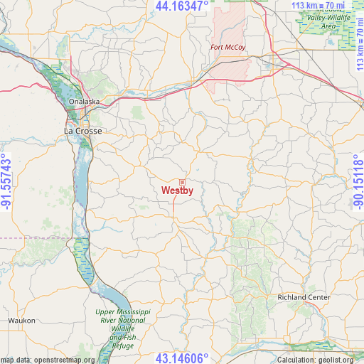
Westby GPS coordinates[2]
43° 39' 24.912" North, 90° 51' 15.48" West
| Map corner | latitude | longitude |
|---|---|---|
| Upper-left | 44.16347°, | -91.55743° |
| Center: | 43.65692°, | -90.8543° |
| Lower-right: | 43.14606°, | -90.15118° |
| Map W x H: | 113.1×113.1 km | = 70.3×70.3mi |
| max Lat: | 71.29058° ⇑13% North |
| Westby: | 43.65692° |
| min Lat: | ⇓87% South 19.06759° |
| min Long | Westby | max Long |
| -171.73463° | -90.8543° | -66.98998° |
| W 38.2%⇐ | ⇒61.8% E |
Elevation
Elevation of Westby is 398 m = 1306 ft, and this is 103.2 m = 339 ft above average elevation for this country.
| Max E: |
3189 m = 10463 ft | 16.4% |
| Westby | 398 m 1306 ft | |
| Avg. | 294.8 m = 967 ft | |
Min E: |
-60 m = -197 ft | 83.6% |
See also: United States elevation on elevation.city.
Geographical zone
Westby is located in North temperate zone (between Tropic of Cancer and the Arctic Circle). Distance of this Northern Tropic circle is 2248.3 km =1397 mi to South.| Distance of | km | miles | from Westby |
|---|---|---|---|
| North Pole | 5152.9 | 3201.9 | to North |
| Arctic Circle | 2547 | 1582.6 | to North |
| Tropic Cancer | 2248.3 | 1397 | to South |
| Equator | 4854.2 | 3016.3 | to South |


Nearby cities:
15 places around Westby: (largest is in red/bold)
• Bangor
28.4 km =17.6 mi,  337°
337°
• Cashton
11.2 km =7 mi,  32°
32°
• Coon Valley
13.7 km =8.5 mi,  291°
291°
• La Farge
19.5 km =12.1 mi,  117°
117°
• Liberty
18.4 km =11.4 mi,  148°
148°
• Norwalk
26.9 km =16.7 mi,  44°
44°
• Ontario
22.5 km =14 mi,  70°
70°
• Portland
12.5 km =7.8 mi,  358°
358°
• Rockland
28.2 km =17.5 mi,  349°
349°
• Saint Joseph
20.8 km =12.9 mi,  313°
313°
• Soldiers Grove
29.8 km =18.5 mi,  167°
167°
• Stoddard
29.3 km =18.2 mi,  271°
271°
• Viola
22.5 km =14 mi,  138°
138°
• Viroqua
11.5 km =7.1 mi,  194°
194°
• Wilton
31.5 km =19.6 mi,  56°
56°
Sources, notices
• [Note1] Compared only with cities in United States existing in our database
• [Src1] Map data: © OpenStreetMap contributors (CC-BY-SA)
• [Src2] Other city data from geonames.org with taken over terms of usage.
• [Src3] Geographical zone / Annual Mean Temperature by Robert A. Rohde @ Wikipedia
