Janesville geodata
Janesville (Wisconsin) is a seat of a second-order administrative division; located in United States in America/Chicago (GMT-5) time zone. With population of 64,123 people, there are 677 cities with bigger population in this country. Compared to other cities in United States, 81.2% of cities are located further ↓South; 56.2% of cities are located further →East and 63.9% of cities have lower elevation than Janesville. Note1


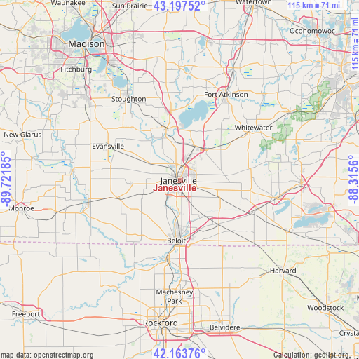
Janesville GPS coordinates[2]
42° 40' 58.044" North, 89° 1' 7.392" West
| Map corner | latitude | longitude |
|---|---|---|
| Upper-left | 43.19752°, | -89.72185° |
| Center: | 42.68279°, | -89.01872° |
| Lower-right: | 42.16376°, | -88.3156° |
| Map W x H: | 114.9×114.9 km | = 71.4×71.4mi |
| max Lat: | 71.29058° ⇑18.8% North |
| Janesville: | 42.68279° |
| min Lat: | ⇓81.2% South 19.06759° |
| min Long | Janesville | max Long |
| -171.73463° | -89.01872° | -66.98998° |
| W 43.8%⇐ | ⇒56.2% E |
Elevation
Elevation of Janesville is 257 m = 843 ft, and this is 37.8 m = 124 ft below average elevation for this country.
| Max E: |
3189 m = 10463 ft | 36.1% |
| Avg. | 294.8 m = 967 ft | |
| Janesville | 257 m = 843 ft | |
Min E: |
-60 m = -197 ft | 63.9% |
See also: Janesville elevation on elevation.city.
Geographical zone
Janesville is located in North temperate zone (between Tropic of Cancer and the Arctic Circle). Distance of this Northern Tropic circle is 2140 km =1329.7 mi to South.| Distance of | km | miles | from Janesville |
|---|---|---|---|
| North Pole | 5261.2 | 3269.2 | to North |
| Arctic Circle | 2655.3 | 1649.9 | to North |
| Tropic Cancer | 2140 | 1329.7 | to South |
| Equator | 4745.9 | 2949 | to South |


Nearby cities:
15 places around Janesville: (largest is in red/bold)
• Beloit
19.4 km =12.1 mi,  183°
183°
• Brodhead
30.1 km =18.7 mi,  256°
256°
• Clinton
18.7 km =11.6 mi,  137°
137°
• Darien
27 km =16.8 mi,  109°
109°
• Edgerton
17.4 km =10.8 mi,  346°
346°
• Evansville
25.3 km =15.7 mi,  295°
295°
• Footville
15.6 km =9.7 mi,  265°
265°
• Lake Koshkonong
26.5 km =16.5 mi,  17°
17°
• Milton
12 km =7.5 mi,  30°
30°
• Orfordville
20.1 km =12.5 mi,  252°
252°
• Richmond
22.3 km =13.9 mi,  80°
80°
• Rockton
26 km =16.2 mi,  189°
189°
• Roscoe
30 km =18.6 mi, 178°
• South Beloit
21.1 km =13.1 mi, 184°
• Whitewater
28.8 km =17.9 mi,  54°
54°
Sources, notices
• [Note1] Compared only with cities in United States existing in our database
• [Src1] Map data: © OpenStreetMap contributors (CC-BY-SA)
• [Src2] Other city data from geonames.org with taken over terms of usage.
• [Src3] Geographical zone / Annual Mean Temperature by Robert A. Rohde @ Wikipedia
