Racine geodata
Racine (Wisconsin) is a seat of a second-order administrative division; located in United States in America/Chicago (GMT-5) time zone. With population of 77,742 people, there are 514 cities with bigger population in this country. Compared to other cities in United States, 81.4% of cities are located further ↓South; 51.8% of cities are located further →East and 51.6% of cities have higher elevation than Racine. Note1


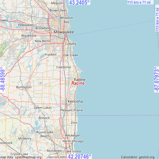
Racine GPS coordinates[2]
42° 43' 34.068" North, 87° 46' 58.26" West
| Map corner | latitude | longitude |
|---|---|---|
| Upper-left | 43.2405°, | -88.48598° |
| Center: | 42.72613°, | -87.78285° |
| Lower-right: | 42.20746°, | -87.07973° |
| Map W x H: | 114.9×114.9 km | = 71.4×71.4mi |
| max Lat: | 71.29058° ⇑18.6% North |
| Racine: | 42.72613° |
| min Lat: | ⇓81.4% South 19.06759° |
| min Long | Racine | max Long |
| -171.73463° | -87.78285° | -66.98998° |
| W 48.2%⇐ | ⇒51.8% E |
Elevation
Elevation of Racine is 192 m = 630 ft, and this is 102.8 m = 337 ft below average elevation for this country.
| Max E: |
3189 m = 10463 ft | 51.6% |
| Avg. | 294.8 m = 967 ft | |
| Racine | 192 m = 630 ft | |
Min E: |
-60 m = -197 ft | 48.4% |
See also: Racine elevation on elevation.city.
Geographical zone
Racine is located in North temperate zone (between Tropic of Cancer and the Arctic Circle). Distance of this Northern Tropic circle is 2144.8 km =1332.7 mi to South.| Distance of | km | miles | from Racine |
|---|---|---|---|
| North Pole | 5256.4 | 3266.2 | to North |
| Arctic Circle | 2650.5 | 1646.9 | to North |
| Tropic Cancer | 2144.8 | 1332.7 | to South |
| Equator | 4750.7 | 2951.9 | to South |


Nearby cities:
15 places around Racine: (largest is in red/bold)
• Caledonia
14.7 km =9.1 mi,  308°
308°
• Cudahy
26.8 km =16.7 mi,  346°
346°
• Franklin
27.6 km =17.1 mi, 310°
• Franksville
11.3 km =7 mi,  289°
289°
• Kenosha
16 km =9.9 mi,  191°
191°
• Mount Pleasant
6.8 km =4.2 mi,  241°
241°
• Oak Creek
18.9 km =11.7 mi,  339°
339°
• Pleasant Prairie
22.8 km =14.2 mi,  212°
212°
• Saint Francis
27.9 km =17.3 mi, 343°
• Somers
14.1 km =8.8 mi,  227°
227°
• South Milwaukee
21.5 km =13.4 mi, 342°
• Sturtevant
9.6 km =6 mi,  251°
251°
• Union Grove
22.4 km =13.9 mi,  259°
259°
• Wind Point
6.6 km =4.1 mi,  11°
11°
• Winthrop Harbor
27.7 km =17.2 mi, 186°
Sources, notices
• [Note1] Compared only with cities in United States existing in our database
• [Src1] Map data: © OpenStreetMap contributors (CC-BY-SA)
• [Src2] Other city data from geonames.org with taken over terms of usage.
• [Src3] Geographical zone / Annual Mean Temperature by Robert A. Rohde @ Wikipedia
