Norwalk geodata
Norwalk (Wisconsin) is a populated place; located in United States in America/Chicago (GMT-5) time zone. With population of 638 people, there are 19285 cities with bigger population in this country. Compared to other cities in United States, 87.7% of cities are located further ↓South; 61.3% of cities are located further →East and 74.5% of cities have lower elevation than Norwalk. Note1


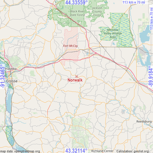
Norwalk GPS coordinates[2]
43° 49' 49.872" North, 90° 37' 17.472" West
| Map corner | latitude | longitude |
|---|---|---|
| Upper-left | 44.33559°, | -91.32465° |
| Center: | 43.83052°, | -90.62152° |
| Lower-right: | 43.32114°, | -89.9184° |
| Map W x H: | 112.8×112.8 km | = 70.1×70.1mi |
| max Lat: | 71.29058° ⇑12.3% North |
| Norwalk: | 43.83052° |
| min Lat: | ⇓87.7% South 19.06759° |
| min Long | Norwalk | max Long |
| -171.73463° | -90.62152° | -66.98998° |
| W 38.7%⇐ | ⇒61.3% E |
Elevation
Elevation of Norwalk is 310 m = 1017 ft, and this is 15.2 m = 50 ft above average elevation for this country.
| Max E: |
3189 m = 10463 ft | 25.5% |
| Norwalk | 310 m 1017 ft | |
| Avg. | 294.8 m = 967 ft | |
Min E: |
-60 m = -197 ft | 74.5% |
See also: United States elevation on elevation.city.
Geographical zone
Norwalk is located in North temperate zone (between Tropic of Cancer and the Arctic Circle). Distance of this Northern Tropic circle is 2267.6 km =1409 mi to South.| Distance of | km | miles | from Norwalk |
|---|---|---|---|
| North Pole | 5133.6 | 3189.9 | to North |
| Arctic Circle | 2527.7 | 1570.6 | to North |
| Tropic Cancer | 2267.6 | 1409 | to South |
| Equator | 4873.5 | 3028.3 | to South |


Nearby cities:
15 places around Norwalk: (largest is in red/bold)
• Bangor
30.4 km =18.9 mi,  283°
283°
• Camp Douglas
29.9 km =18.6 mi,  69°
69°
• Cashton
16 km =9.9 mi,  232°
232°
• Elroy
29.8 km =18.5 mi,  109°
109°
• Greenwood
33.8 km =21 mi,  151°
151°
• Hillsboro
29.8 km =18.5 mi,  131°
131°
• La Farge
28.5 km =17.7 mi,  183°
183°
• Ontario
11.9 km =7.4 mi,  168°
168°
• Portland
20.2 km =12.6 mi,  250°
250°
• Rockland
25.3 km =15.7 mi,  289°
289°
• Saint Joseph
34.1 km =21.2 mi,  261°
261°
• Sparta
19.9 km =12.4 mi,  309°
309°
• Tomah
19 km =11.8 mi,  29°
29°
• Westby
26.9 km =16.7 mi,  224°
224°
• Wilton
7.7 km =4.8 mi,  104°
104°
Sources, notices
• [Note1] Compared only with cities in United States existing in our database
• [Src1] Map data: © OpenStreetMap contributors (CC-BY-SA)
• [Src2] Other city data from geonames.org with taken over terms of usage.
• [Src3] Geographical zone / Annual Mean Temperature by Robert A. Rohde @ Wikipedia
