Wilton geodata
Wilton (Wisconsin) is a populated place; located in United States in America/Chicago (GMT-5) time zone. With population of 506 people, there are 20811 cities with bigger population in this country. Compared to other cities in United States, 87.7% of cities are located further ↓South; 61% of cities are located further →East and 73.5% of cities have lower elevation than Wilton. Note1


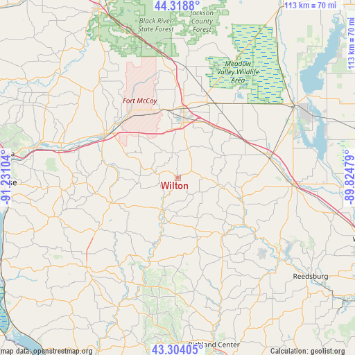
Wilton GPS coordinates[2]
43° 48' 48.888" North, 90° 31' 40.476" West
| Map corner | latitude | longitude |
|---|---|---|
| Upper-left | 44.3188°, | -91.23104° |
| Center: | 43.81358°, | -90.52791° |
| Lower-right: | 43.30405°, | -89.82479° |
| Map W x H: | 112.8×112.8 km | = 70.1×70.1mi |
| max Lat: | 71.29058° ⇑12.3% North |
| Wilton: | 43.81358° |
| min Lat: | ⇓87.7% South 19.06759° |
| min Long | Wilton | max Long |
| -171.73463° | -90.52791° | -66.98998° |
| W 39%⇐ | ⇒61% E |
Elevation
Elevation of Wilton is 304 m = 997 ft, and this is 9.2 m = 30 ft above average elevation for this country.
| Max E: |
3189 m = 10463 ft | 26.5% |
| Wilton | 304 m 997 ft | |
| Avg. | 294.8 m = 967 ft | |
Min E: |
-60 m = -197 ft | 73.5% |
See also: United States elevation on elevation.city.
Geographical zone
Wilton is located in North temperate zone (between Tropic of Cancer and the Arctic Circle). Distance of this Northern Tropic circle is 2265.7 km =1407.8 mi to South.| Distance of | km | miles | from Wilton |
|---|---|---|---|
| North Pole | 5135.4 | 3191 | to North |
| Arctic Circle | 2529.6 | 1571.8 | to North |
| Tropic Cancer | 2265.7 | 1407.8 | to South |
| Equator | 4871.6 | 3027.1 | to South |


Nearby cities:
15 places around Wilton: (largest is in red/bold)
• Camp Douglas
23.9 km =14.9 mi,  59°
59°
• Cashton
21.7 km =13.5 mi,  248°
248°
• Elroy
22.1 km =13.7 mi,  111°
111°
• Greenwood
29.1 km =18.1 mi,  162°
162°
• Hillsboro
23.2 km =14.4 mi,  140°
140°
• La Farge
28.1 km =17.5 mi,  198°
198°
• New Lisbon
30 km =18.6 mi,  75°
75°
• Norwalk
7.7 km =4.8 mi,  284°
284°
• Ontario
11 km =6.8 mi,  207°
207°
• Portland
27 km =16.8 mi,  259°
259°
• Rockland
33 km =20.5 mi,  288°
288°
• Sparta
27.1 km =16.8 mi,  302°
302°
• Tomah
18.4 km =11.4 mi,  5°
5°
• Westby
31.5 km =19.6 mi,  236°
236°
• Wonewoc
30.3 km =18.8 mi,  126°
126°
Sources, notices
• [Note1] Compared only with cities in United States existing in our database
• [Src1] Map data: © OpenStreetMap contributors (CC-BY-SA)
• [Src2] Other city data from geonames.org with taken over terms of usage.
• [Src3] Geographical zone / Annual Mean Temperature by Robert A. Rohde @ Wikipedia
