Pinon geodata
Pinon (Arizona) is a populated place; located in United States in America/Denver (GMT-6) time zone. With population of 904 people, there are 16951 cities with bigger population in this country. Compared to other cities in United States, 69.9% of cities are located further ↑North; 85.9% of cities are located further →East and 98.9% of cities have lower elevation than Pinon. Note1


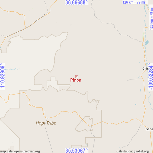
Pinon GPS coordinates[2]
36° 6' 2.988" North, 110° 13' 33.456" West
| Map corner | latitude | longitude |
|---|---|---|
| Upper-left | 36.66688°, | -110.92909° |
| Center: | 36.10083°, | -110.22596° |
| Lower-right: | 35.53067°, | -109.52284° |
| Map W x H: | 126.3×126.3 km | = 78.5×78.5mi |
| max Lat: | 71.29058° ⇑69.9% North |
| Pinon: | 36.10083° |
| min Lat: | ⇓30.1% South 19.06759° |
| min Long | Pinon | max Long |
| -171.73463° | -110.22596° | -66.98998° |
| W 14.1%⇐ | ⇒85.9% E |
Elevation
Elevation of Pinon is 1943 m = 6375 ft, and this is 1648.2 m = 5407 ft above average elevation for this country.
| Max E: |
3189 m = 10463 ft | 1.1% |
| Pinon | 1943 m 6375 ft | |
| Avg. | 294.8 m = 967 ft | |
Min E: |
-60 m = -197 ft | 98.9% |
See also: United States elevation on elevation.city.
Geographical zone
Pinon is located in North temperate zone (between Tropic of Cancer and the Arctic Circle). Distance of this Northern Tropic circle is 1408.1 km =875 mi to South.| Distance of | km | miles | from Pinon |
|---|---|---|---|
| North Pole | 5993 | 3723.9 | to North |
| Arctic Circle | 3387.1 | 2104.6 | to North |
| Tropic Cancer | 1408.1 | 875 | to South |
| Equator | 4014 | 2494.2 | to South |


Nearby cities:
15 places around Pinon: (largest is in red/bold)
• Burnside
66.7 km =41.4 mi,  125°
125°
• Chilchinbito
49.1 km =30.5 mi,  15°
15°
• Chinle
60.8 km =37.8 mi,  84°
84°
• First Mesa
32.5 km =20.2 mi,  205°
205°
• Hotevilla-Bacavi
44.6 km =27.7 mi,  244°
244°
• Kayenta
69.8 km =43.4 mi,  357°
357°
• Kykotsmovi Village
43.8 km =27.2 mi,  234°
234°
• Low Mountain
20.5 km =12.7 mi,  150°
150°
• Many Farms
61.3 km =38.1 mi,  62°
62°
• Second Mesa
42.4 km =26.3 mi,  216°
216°
• Shongopovi
42 km =26.1 mi, 221°
• Shonto
66.4 km =41.3 mi,  325°
325°
• Shungopavi
42.6 km =26.5 mi, 219°
• Tonalea
70.6 km =43.9 mi,  290°
290°
• White Cone
56.9 km =35.4 mi,  165°
165°
Sources, notices
• [Note1] Compared only with cities in United States existing in our database
• [Src1] Map data: © OpenStreetMap contributors (CC-BY-SA)
• [Src2] Other city data from geonames.org with taken over terms of usage.
• [Src3] Geographical zone / Annual Mean Temperature by Robert A. Rohde @ Wikipedia
