Window Rock geodata
Window Rock (Arizona) is a populated place; located in United States in America/Denver (GMT-6) time zone. With population of 2,712 people, there are 10154 cities with bigger population in this country. Compared to other cities in United States, 71.9% of cities are located further ↑North; 85.4% of cities are located further →East and 99.4% of cities have lower elevation than Window Rock. Note1


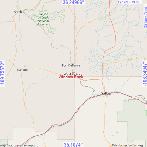
Window Rock GPS coordinates[2]
35° 40' 50.052" North, 109° 3' 9.324" West
| Map corner | latitude | longitude |
|---|---|---|
| Upper-left | 36.24966°, | -109.75572° |
| Center: | 35.68057°, | -109.05259° |
| Lower-right: | 35.1074°, | -108.34947° |
| Map W x H: | 127×127 km | = 78.9×78.9mi |
| max Lat: | 71.29058° ⇑71.9% North |
| Window Rock: | 35.68057° |
| min Lat: | ⇓28.1% South 19.06759° |
| min Long | Window Rock | max Long |
| -171.73463° | -109.05259° | -66.98998° |
| W 14.6%⇐ | ⇒85.4% E |
Elevation
Elevation of Window Rock is 2105 m = 6906 ft, and this is 1810.2 m = 5939 ft above average elevation for this country.
| Max E: |
3189 m = 10463 ft | 0.59999999999999% |
| Window Rock | 2105 m 6906 ft | |
| Avg. | 294.8 m = 967 ft | |
Min E: |
-60 m = -197 ft | 99.4% |
See also: United States elevation on elevation.city.
Geographical zone
Window Rock is located in North temperate zone (between Tropic of Cancer and the Arctic Circle). Distance of this Northern Tropic circle is 1361.4 km =845.9 mi to South.| Distance of | km | miles | from Window Rock |
|---|---|---|---|
| North Pole | 6039.8 | 3753 | to North |
| Arctic Circle | 3433.9 | 2133.7 | to North |
| Tropic Cancer | 1361.4 | 845.9 | to South |
| Equator | 3967.3 | 2465.2 | to South |


Nearby cities:
15 places around Window Rock: (largest is in red/bold)
• Burnside
52.2 km =32.4 mi,  278°
278°
• Chinle
69.3 km =43.1 mi,  319°
319°
• Church Rock
44.1 km =27.4 mi,  111°
111°
• Fort Defiance
7.4 km =4.6 mi,  343°
343°
• Gallup
32.8 km =20.4 mi,  121°
121°
• Ganado
44.3 km =27.5 mi,  274°
274°
• Houck
46.4 km =28.8 mi,  197°
197°
• Navajo
24.5 km =15.2 mi,  3°
3°
• Rock Springs
21.7 km =13.5 mi, 111°
• Saint Michaels
5.6 km =3.5 mi,  224°
224°
• Sanders
57.5 km =35.7 mi,  206°
206°
• Sawmill
26.7 km =16.6 mi, 337°
• Tohatchi
32.9 km =20.4 mi,  52°
52°
• Twin Lakes
25.3 km =15.7 mi,  82°
82°
• Yah-ta-hey
25.3 km =15.7 mi,  103°
103°
Sources, notices
• [Note1] Compared only with cities in United States existing in our database
• [Src1] Map data: © OpenStreetMap contributors (CC-BY-SA)
• [Src2] Other city data from geonames.org with taken over terms of usage.
• [Src3] Geographical zone / Annual Mean Temperature by Robert A. Rohde @ Wikipedia
