Cornville geodata
Cornville (Arizona) is a populated place; located in United States in America/Phoenix (GMT-7) time zone. With population of 3,280 people, there are 9183 cities with bigger population in this country. Compared to other cities in United States, 76.7% of cities are located further ↑North; 87.3% of cities are located further →East and 93.5% of cities have lower elevation than Cornville. Note1


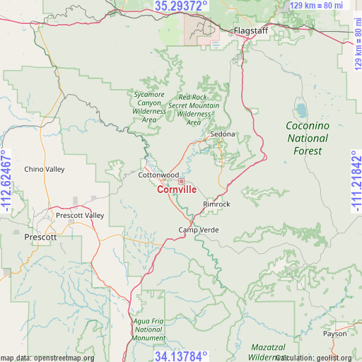
Cornville GPS coordinates[2]
34° 43' 4.08" North, 111° 55' 17.544" West
| Map corner | latitude | longitude |
|---|---|---|
| Upper-left | 35.29372°, | -112.62467° |
| Center: | 34.7178°, | -111.92154° |
| Lower-right: | 34.13784°, | -111.21842° |
| Map W x H: | 128.5×128.5 km | = 79.8×79.8mi |
| max Lat: | 71.29058° ⇑76.7% North |
| Cornville: | 34.7178° |
| min Lat: | ⇓23.3% South 19.06759° |
| min Long | Cornville | max Long |
| -171.73463° | -111.92154° | -66.98998° |
| W 12.7%⇐ | ⇒87.3% E |
Elevation
Elevation of Cornville is 1011 m = 3317 ft, and this is 716.2 m = 2350 ft above average elevation for this country.
| Max E: |
3189 m = 10463 ft | 6.5% |
| Cornville | 1011 m 3317 ft | |
| Avg. | 294.8 m = 967 ft | |
Min E: |
-60 m = -197 ft | 93.5% |
See also: United States elevation on elevation.city.
Geographical zone
Cornville is located in North temperate zone (between Tropic of Cancer and the Arctic Circle). Distance of this Northern Tropic circle is 1254.3 km =779.4 mi to South.| Distance of | km | miles | from Cornville |
|---|---|---|---|
| North Pole | 6146.8 | 3819.4 | to North |
| Arctic Circle | 3540.9 | 2200.2 | to North |
| Tropic Cancer | 1254.3 | 779.4 | to South |
| Equator | 3860.3 | 2398.7 | to South |


Nearby cities:
15 places around Cornville: (largest is in red/bold)
• Big Park
16.1 km =10 mi,  64°
64°
• Camp Verde
18.2 km =11.3 mi,  160°
160°
• Clarkdale
13.8 km =8.6 mi,  295°
295°
• Cottonwood
8.4 km =5.2 mi,  286°
286°
• Dewey-Humboldt
36 km =22.4 mi,  234°
234°
• Kachina Village
47 km =29.2 mi,  26°
26°
• Lake Montezuma
16.2 km =10.1 mi,  125°
125°
• Mayer
45.8 km =28.5 mi,  219°
219°
• Munds Park
36.1 km =22.4 mi,  45°
45°
• Prescott Valley
38 km =23.6 mi,  251°
251°
• Sedona
22.4 km =13.9 mi,  40°
40°
• Spring Valley
46.8 km =29.1 mi,  207°
207°
• Verde Village
8.3 km =5.2 mi,  264°
264°
• Village of Oak Creek (Big Park)
16.2 km =10.1 mi, 64°
• West Sedona
19.7 km =12.2 mi, 32°
Sources, notices
• [Note1] Compared only with cities in United States existing in our database
• [Src1] Map data: © OpenStreetMap contributors (CC-BY-SA)
• [Src2] Other city data from geonames.org with taken over terms of usage.
• [Src3] Geographical zone / Annual Mean Temperature by Robert A. Rohde @ Wikipedia
