Dewey-Humboldt geodata
Dewey-Humboldt (Arizona) is a populated place; located in United States in America/Phoenix (GMT-7) time zone. With population of 3,894 people, there are 8335 cities with bigger population in this country. Compared to other cities in United States, 77.5% of cities are located further ↑North; 87.9% of cities are located further →East and 96% of cities have lower elevation than Dewey-Humboldt. Note1


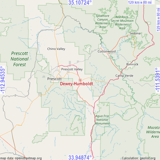
Dewey-Humboldt GPS coordinates[2]
34° 31' 48" North, 112° 14' 31.992" West
| Map corner | latitude | longitude |
|---|---|---|
| Upper-left | 35.10724°, | -112.94535° |
| Center: | 34.53°, | -112.24222° |
| Lower-right: | 33.94874°, | -111.5391° |
| Map W x H: | 128.8×128.8 km | = 80×80mi |
| max Lat: | 71.29058° ⇑77.5% North |
| Dewey-Humboldt: | 34.53° |
| min Lat: | ⇓22.5% South 19.06759° |
| min Long | Dewey-Humboldt | max Long |
| -171.73463° | -112.24222° | -66.98998° |
| W 12.1%⇐ | ⇒87.9% E |
Elevation
Elevation of Dewey-Humboldt is 1395 m = 4577 ft, and this is 1100.2 m = 3610 ft above average elevation for this country.
| Max E: |
3189 m = 10463 ft | 4% |
| Dewey-Humboldt | 1395 m 4577 ft | |
| Avg. | 294.8 m = 967 ft | |
Min E: |
-60 m = -197 ft | 96% |
See also: United States elevation on elevation.city.
Geographical zone
Dewey-Humboldt is located in North temperate zone (between Tropic of Cancer and the Arctic Circle). Distance of this Northern Tropic circle is 1233.5 km =766.5 mi to South.| Distance of | km | miles | from Dewey-Humboldt |
|---|---|---|---|
| North Pole | 6167.7 | 3832.4 | to North |
| Arctic Circle | 3561.8 | 2213.2 | to North |
| Tropic Cancer | 1233.5 | 766.5 | to South |
| Equator | 3839.4 | 2385.7 | to South |


Nearby cities:
15 places around Dewey-Humboldt: (largest is in red/bold)
• Camp Verde
35.7 km =22.2 mi,  83°
83°
• Chino Valley
31.9 km =19.8 mi,  322°
322°
• Clarkdale
31.7 km =19.7 mi,  32°
32°
• Cordes Lakes
27.8 km =17.3 mi,  152°
152°
• Cornville
36 km =22.4 mi,  54°
54°
• Cottonwood
31.5 km =19.6 mi,  42°
42°
• Lake Montezuma
44 km =27.3 mi, 75°
• Mayer
14.7 km =9.1 mi,  177°
177°
• Paulden
44.6 km =27.7 mi,  332°
332°
• Prescott
20.8 km =12.9 mi,  273°
273°
• Prescott Valley
11.2 km =7 mi, 322°
• Spring Valley
21.9 km =13.6 mi,  159°
159°
• Verde Village
29.1 km =18.1 mi, 46°
• Wilhoit
33.6 km =20.9 mi,  249°
249°
• Williamson
32.6 km =20.3 mi,  303°
303°
Sources, notices
• [Note1] Compared only with cities in United States existing in our database
• [Src1] Map data: © OpenStreetMap contributors (CC-BY-SA)
• [Src2] Other city data from geonames.org with taken over terms of usage.
• [Src3] Geographical zone / Annual Mean Temperature by Robert A. Rohde @ Wikipedia
