Big Park geodata
Big Park (Arizona) is a populated place; located in United States in America/Phoenix (GMT-7) time zone. With population of 6,695 people, there are 5979 cities with bigger population in this country. Compared to other cities in United States, 76.5% of cities are located further ↑North; 86.9% of cities are located further →East and 94.8% of cities have lower elevation than Big Park. Note1


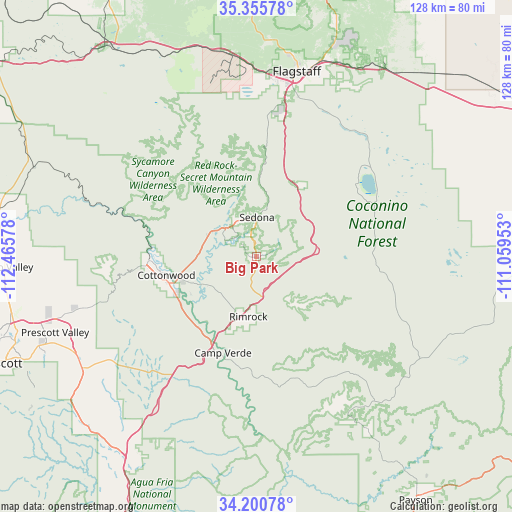
Big Park GPS coordinates[2]
34° 46' 49.08" North, 111° 45' 45.54" West
| Map corner | latitude | longitude |
|---|---|---|
| Upper-left | 35.35578°, | -112.46578° |
| Center: | 34.7803°, | -111.76265° |
| Lower-right: | 34.20078°, | -111.05953° |
| Map W x H: | 128.4×128.4 km | = 79.8×79.8mi |
| max Lat: | 71.29058° ⇑76.5% North |
| Big Park: | 34.7803° |
| min Lat: | ⇓23.5% South 19.06759° |
| min Long | Big Park | max Long |
| -171.73463° | -111.76265° | -66.98998° |
| W 13.1%⇐ | ⇒86.9% E |
Elevation
Elevation of Big Park is 1239 m = 4065 ft, and this is 944.2 m = 3098 ft above average elevation for this country.
| Max E: |
3189 m = 10463 ft | 5.2% |
| Big Park | 1239 m 4065 ft | |
| Avg. | 294.8 m = 967 ft | |
Min E: |
-60 m = -197 ft | 94.8% |
See also: United States elevation on elevation.city.
Geographical zone
Big Park is located in North temperate zone (between Tropic of Cancer and the Arctic Circle). Distance of this Northern Tropic circle is 1261.3 km =783.7 mi to South.| Distance of | km | miles | from Big Park |
|---|---|---|---|
| North Pole | 6139.9 | 3815.2 | to North |
| Arctic Circle | 3534 | 2195.9 | to North |
| Tropic Cancer | 1261.3 | 783.7 | to South |
| Equator | 3867.2 | 2403 | to South |


Nearby cities:
15 places around Big Park: (largest is in red/bold)
• Camp Verde
25.5 km =15.8 mi,  199°
199°
• Clarkdale
27 km =16.8 mi,  267°
267°
• Cornville
16.1 km =10 mi,  244°
244°
• Cottonwood
23 km =14.3 mi,  258°
258°
• Dewey-Humboldt
51.9 km =32.2 mi, 237°
• Flagstaff
47.5 km =29.5 mi,  12°
12°
• Kachina Village
35.8 km =22.2 mi, 10°
• Lake Montezuma
16.5 km =10.3 mi,  184°
184°
• Mountainaire
35 km =21.7 mi, 14°
• Munds Park
21.5 km =13.4 mi,  31°
31°
• Sedona
9.9 km =6.2 mi,  0°
0°
• Strawberry
48.2 km =30 mi,  149°
149°
• Verde Village
24 km =14.9 mi,  251°
251°
• Village of Oak Creek (Big Park)
0.1 km =0.1 mi, 27°
• West Sedona
10.4 km =6.5 mi,  338°
338°
Sources, notices
• [Note1] Compared only with cities in United States existing in our database
• [Src1] Map data: © OpenStreetMap contributors (CC-BY-SA)
• [Src2] Other city data from geonames.org with taken over terms of usage.
• [Src3] Geographical zone / Annual Mean Temperature by Robert A. Rohde @ Wikipedia
