Mayer geodata
Mayer (Arizona) is a populated place; located in United States in America/Phoenix (GMT-7) time zone. With population of 1,497 people, there are 13666 cities with bigger population in this country. Compared to other cities in United States, 78.1% of cities are located further ↑North; 87.9% of cities are located further →East and 95.6% of cities have lower elevation than Mayer. Note1


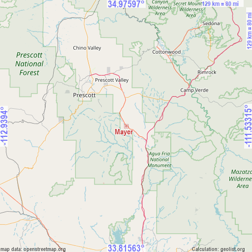
Mayer GPS coordinates[2]
34° 23' 52.116" North, 112° 14' 10.572" West
| Map corner | latitude | longitude |
|---|---|---|
| Upper-left | 34.97597°, | -112.9394° |
| Center: | 34.39781°, | -112.23627° |
| Lower-right: | 33.81563°, | -111.53315° |
| Map W x H: | 129×129 km | = 80.2×80.2mi |
| max Lat: | 71.29058° ⇑78.1% North |
| Mayer: | 34.39781° |
| min Lat: | ⇓21.9% South 19.06759° |
| min Long | Mayer | max Long |
| -171.73463° | -112.23627° | -66.98998° |
| W 12.1%⇐ | ⇒87.9% E |
Elevation
Elevation of Mayer is 1353 m = 4439 ft, and this is 1058.2 m = 3472 ft above average elevation for this country.
| Max E: |
3189 m = 10463 ft | 4.4% |
| Mayer | 1353 m 4439 ft | |
| Avg. | 294.8 m = 967 ft | |
Min E: |
-60 m = -197 ft | 95.6% |
See also: United States elevation on elevation.city.
Geographical zone
Mayer is located in North temperate zone (between Tropic of Cancer and the Arctic Circle). Distance of this Northern Tropic circle is 1218.8 km =757.3 mi to South.| Distance of | km | miles | from Mayer |
|---|---|---|---|
| North Pole | 6182.4 | 3841.6 | to North |
| Arctic Circle | 3576.5 | 2222.3 | to North |
| Tropic Cancer | 1218.8 | 757.3 | to South |
| Equator | 3824.7 | 2376.6 | to South |


Nearby cities:
15 places around Mayer: (largest is in red/bold)
• Black Canyon City
37.2 km =23.1 mi,  167°
167°
• Camp Verde
39.6 km =24.6 mi,  62°
62°
• Chino Valley
44.7 km =27.8 mi,  333°
333°
• Clarkdale
44.6 km =27.7 mi,  21°
21°
• Cordes Lakes
15.8 km =9.8 mi,  129°
129°
• Cornville
45.8 km =28.5 mi,  39°
39°
• Cottonwood
43.2 km =26.8 mi,  28°
28°
• Dewey-Humboldt
14.7 km =9.1 mi,  357°
357°
• Lake Montezuma
49.4 km =30.7 mi, 58°
• Prescott
26.5 km =16.5 mi,  306°
306°
• Prescott Valley
24.7 km =15.3 mi,  342°
342°
• Spring Valley
9.2 km =5.7 mi, 129°
• Verde Village
40.4 km =25.1 mi, 30°
• Wilhoit
32.3 km =20.1 mi,  275°
275°
• Williamson
42.8 km =26.6 mi,  319°
319°
Sources, notices
• [Note1] Compared only with cities in United States existing in our database
• [Src1] Map data: © OpenStreetMap contributors (CC-BY-SA)
• [Src2] Other city data from geonames.org with taken over terms of usage.
• [Src3] Geographical zone / Annual Mean Temperature by Robert A. Rohde @ Wikipedia
