First Mesa geodata
First Mesa (Arizona) is a populated place; located in United States in America/Phoenix (GMT-7) time zone. With population of 1,555 people, there are 13456 cities with bigger population in this country. Compared to other cities in United States, 71.1% of cities are located further ↑North; 85.9% of cities are located further →East and 98.2% of cities have lower elevation than First Mesa. Note1


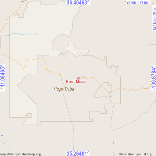
First Mesa GPS coordinates[2]
35° 50' 12.012" North, 110° 22' 53.472" West
| Map corner | latitude | longitude |
|---|---|---|
| Upper-left | 36.40463°, | -111.08465° |
| Center: | 35.83667°, | -110.38152° |
| Lower-right: | 35.26461°, | -109.6784° |
| Map W x H: | 126.8×126.8 km | = 78.8×78.8mi |
| max Lat: | 71.29058° ⇑71.1% North |
| First Mesa: | 35.83667° |
| min Lat: | ⇓28.9% South 19.06759° |
| min Long | First Mesa | max Long |
| -171.73463° | -110.38152° | -66.98998° |
| W 14.1%⇐ | ⇒85.9% E |
Elevation
Elevation of First Mesa is 1766 m = 5794 ft, and this is 1471.2 m = 4827 ft above average elevation for this country.
| Max E: |
3189 m = 10463 ft | 1.8% |
| First Mesa | 1766 m 5794 ft | |
| Avg. | 294.8 m = 967 ft | |
Min E: |
-60 m = -197 ft | 98.2% |
See also: United States elevation on elevation.city.
Geographical zone
First Mesa is located in North temperate zone (between Tropic of Cancer and the Arctic Circle). Distance of this Northern Tropic circle is 1378.7 km =856.7 mi to South.| Distance of | km | miles | from First Mesa |
|---|---|---|---|
| North Pole | 6022.4 | 3742.1 | to North |
| Arctic Circle | 3416.5 | 2122.9 | to North |
| Tropic Cancer | 1378.7 | 856.7 | to South |
| Equator | 3984.7 | 2476 | to South |


Nearby cities:
15 places around First Mesa: (largest is in red/bold)
• Burnside
68.9 km =42.8 mi,  97°
97°
• Chilchinbito
81.3 km =50.5 mi,  19°
19°
• Dilkon
50.5 km =31.4 mi,  173°
173°
• Ganado
77 km =47.8 mi, 100°
• Greasewood
58.8 km =36.5 mi,  126°
126°
• Hotevilla-Bacavi
28.1 km =17.5 mi,  291°
291°
• Kykotsmovi Village
22.2 km =13.8 mi,  280°
280°
• Low Mountain
26.8 km =16.7 mi,  64°
64°
• Moenkopi
81.6 km =50.7 mi, 291°
• Pinon
32.5 km =20.2 mi,  25°
25°
• Second Mesa
12.1 km =7.5 mi,  246°
246°
• Shongopovi
14 km =8.7 mi,  261°
261°
• Shungopavi
13.6 km =8.5 mi, 255°
• Tonalea
75.2 km =46.7 mi,  315°
315°
• White Cone
38.2 km =23.7 mi, 132°
Sources, notices
• [Note1] Compared only with cities in United States existing in our database
• [Src1] Map data: © OpenStreetMap contributors (CC-BY-SA)
• [Src2] Other city data from geonames.org with taken over terms of usage.
• [Src3] Geographical zone / Annual Mean Temperature by Robert A. Rohde @ Wikipedia
