Moenkopi geodata
Moenkopi (Arizona) is a populated place; located in United States in America/Phoenix (GMT-7) time zone. With population of 964 people, there are 16535 cities with bigger population in this country. Compared to other cities in United States, 69.8% of cities are located further ↑North; 86.4% of cities are located further →East and 96.3% of cities have lower elevation than Moenkopi. Note1


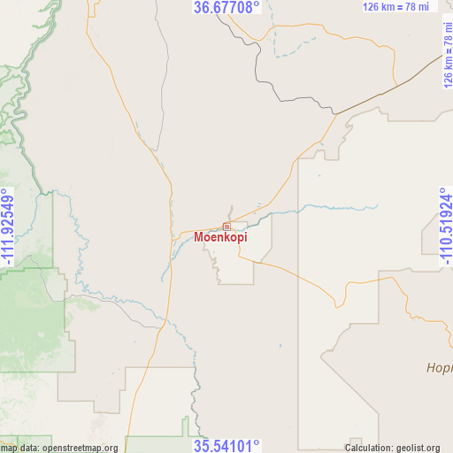
Moenkopi GPS coordinates[2]
36° 6' 39.96" North, 111° 13' 20.496" West
| Map corner | latitude | longitude |
|---|---|---|
| Upper-left | 36.67708°, | -111.92549° |
| Center: | 36.1111°, | -111.22236° |
| Lower-right: | 35.54101°, | -110.51924° |
| Map W x H: | 126.3×126.3 km | = 78.5×78.5mi |
| max Lat: | 71.29058° ⇑69.8% North |
| Moenkopi: | 36.1111° |
| min Lat: | ⇓30.2% South 19.06759° |
| min Long | Moenkopi | max Long |
| -171.73463° | -111.22236° | -66.98998° |
| W 13.6%⇐ | ⇒86.4% E |
Elevation
Elevation of Moenkopi is 1457 m = 4780 ft, and this is 1162.2 m = 3813 ft above average elevation for this country.
| Max E: |
3189 m = 10463 ft | 3.7% |
| Moenkopi | 1457 m 4780 ft | |
| Avg. | 294.8 m = 967 ft | |
Min E: |
-60 m = -197 ft | 96.3% |
See also: United States elevation on elevation.city.
Geographical zone
Moenkopi is located in North temperate zone (between Tropic of Cancer and the Arctic Circle). Distance of this Northern Tropic circle is 1409.3 km =875.7 mi to South.| Distance of | km | miles | from Moenkopi |
|---|---|---|---|
| North Pole | 5991.9 | 3723.2 | to North |
| Arctic Circle | 3386 | 2104 | to North |
| Tropic Cancer | 1409.3 | 875.7 | to South |
| Equator | 4015.2 | 2494.9 | to South |


Nearby cities:
15 places around Moenkopi: (largest is in red/bold)
• Cameron
31.3 km =19.4 mi,  213°
213°
• First Mesa
81.6 km =50.7 mi,  111°
111°
• Grand Canyon
82.6 km =51.3 mi,  265°
265°
• Grand Canyon Village
84 km =52.2 mi, 265°
• Hotevilla-Bacavi
53.5 km =33.2 mi, 112°
• Kaibito
55.7 km =34.6 mi,  13°
13°
• Kykotsmovi Village
60 km =37.3 mi,  116°
116°
• LeChee
85.8 km =53.3 mi,  346°
346°
• Second Mesa
73.6 km =45.7 mi, 118°
• Shongopovi
69.9 km =43.4 mi, 117°
• Shonto
74.7 km =46.4 mi,  44°
44°
• Shungopavi
71.1 km =44.2 mi, 118°
• Tonalea
33 km =20.5 mi, 44°
• Tuba City
3.1 km =1.9 mi,  329°
329°
• Tusayan
82.7 km =51.4 mi,  259°
259°
Sources, notices
• [Note1] Compared only with cities in United States existing in our database
• [Src1] Map data: © OpenStreetMap contributors (CC-BY-SA)
• [Src2] Other city data from geonames.org with taken over terms of usage.
• [Src3] Geographical zone / Annual Mean Temperature by Robert A. Rohde @ Wikipedia
